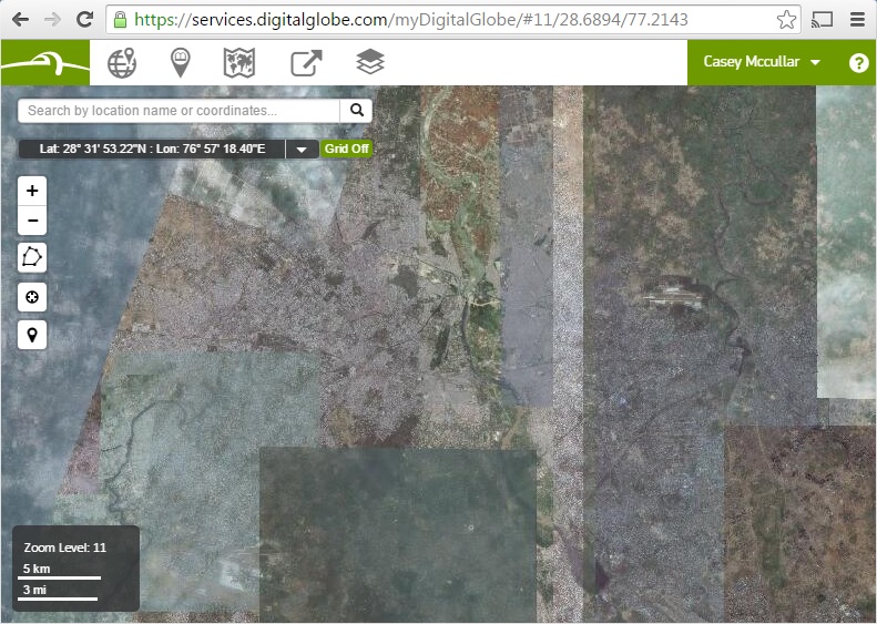
 A snapshot of Basemap over New Delhi, India – a patchwork of images that users can view or download to better understand a specific area.[/caption]
[caption id="attachment_3622" align="alignleft" width="400"]
A snapshot of Basemap over New Delhi, India – a patchwork of images that users can view or download to better understand a specific area.[/caption]
[caption id="attachment_3622" align="alignleft" width="400"] The same area seen as Basemap +Vivid – one unified image that merges the patches together for a single view of the whole landscape.[/caption]
But creating this view is not easy. Imagery pros will tell you it’s really, really difficult to build a large imagery mosaic because of inconsistencies between images: jarring misalignment, evident seam lines, inconsistent color balancing, mixed seasonality, and heavy haze or cloud cover. All of these issues exist when building a mosaic of just two images, but the job gets exponentially more difficult when thousands of images are required to cover a large region at 50-centimeter resolution.
The first step is just to assemble enough content to build this type of view, and only DigitalGlobe has an archive with millions of high-resolution images of our planet dating back to 1999. Then you need a staff of highly trained photogrammetrists to do the required specialized image processing, which, fortunately, we have on site. Additionally, our R&D teams created some amazing, patented algorithms that give us the ability to do things at scale with imagery that literally nobody else can do. The hard work of our image scientists paid off with a consistently beautiful picture of the earth, whether zoomed out to view an entire country or zoomed in all the way down to a 50 cm resolution view.
Different groups of customers value this for different kinds of applications. Organizations that build consumer-facing applications that require an intuitive end user experience value Basemap +Vivid because they want to keep their users engaged in their application, not distracted by inconsistencies in the imagery. Government agencies and global development organizations value Basemap +Vivid for map-building purposes, and creating value-added information like road vectors or population polygons. Developers can use +Vivid online or host it in their own infrastructure or secure environment, which makes it easy for a variety of users to access Basemap.
We’re still building this version 2.0, beautiful image layer of the world, country by country. A few months ago, we completed coverage for the entire continent of Africa. This summer, we’ll finish all of Europe, and we’ll tackle North America before the year is over. Once we’ve finished building a country, it’s ready to use with no hidden costs of ownership, so customers spend their time focused on using the content, not bogged down in technical details.
Our next post in this series will explore version 3.0 of DigitalGlobe Basemap, where imagery gets onto the screens and into the hands of our users with lightning speed.
Casey McCullar is Director of Product Marketing at DigitalGlobe.
The same area seen as Basemap +Vivid – one unified image that merges the patches together for a single view of the whole landscape.[/caption]
But creating this view is not easy. Imagery pros will tell you it’s really, really difficult to build a large imagery mosaic because of inconsistencies between images: jarring misalignment, evident seam lines, inconsistent color balancing, mixed seasonality, and heavy haze or cloud cover. All of these issues exist when building a mosaic of just two images, but the job gets exponentially more difficult when thousands of images are required to cover a large region at 50-centimeter resolution.
The first step is just to assemble enough content to build this type of view, and only DigitalGlobe has an archive with millions of high-resolution images of our planet dating back to 1999. Then you need a staff of highly trained photogrammetrists to do the required specialized image processing, which, fortunately, we have on site. Additionally, our R&D teams created some amazing, patented algorithms that give us the ability to do things at scale with imagery that literally nobody else can do. The hard work of our image scientists paid off with a consistently beautiful picture of the earth, whether zoomed out to view an entire country or zoomed in all the way down to a 50 cm resolution view.
Different groups of customers value this for different kinds of applications. Organizations that build consumer-facing applications that require an intuitive end user experience value Basemap +Vivid because they want to keep their users engaged in their application, not distracted by inconsistencies in the imagery. Government agencies and global development organizations value Basemap +Vivid for map-building purposes, and creating value-added information like road vectors or population polygons. Developers can use +Vivid online or host it in their own infrastructure or secure environment, which makes it easy for a variety of users to access Basemap.
We’re still building this version 2.0, beautiful image layer of the world, country by country. A few months ago, we completed coverage for the entire continent of Africa. This summer, we’ll finish all of Europe, and we’ll tackle North America before the year is over. Once we’ve finished building a country, it’s ready to use with no hidden costs of ownership, so customers spend their time focused on using the content, not bogged down in technical details.
Our next post in this series will explore version 3.0 of DigitalGlobe Basemap, where imagery gets onto the screens and into the hands of our users with lightning speed.
Casey McCullar is Director of Product Marketing at DigitalGlobe.