Here are three particularly exciting projects we’ve collaborated on so far.
[caption id="attachment_4438" align="alignleft" width="350"]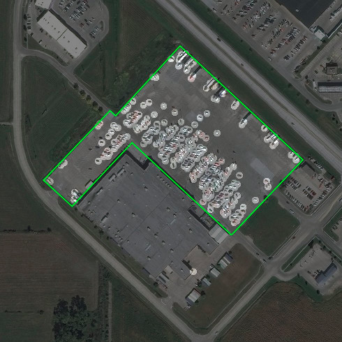 Can you count 460 million cars in a day? Spaceknow can. Imagery ©DigitalGlobe 2016[/caption]
Counting cars, lots of them
The data supplied to Spaceknow’s proprietary Object Detection feature seen below provides analysis of satellite imagery at a peak rate of up to 460 million cars per day. DigitalGlobe imagery has been invaluable to Spaceknow’s economic analytics and used in a range of projects, from forecasting regional revenues to planning estimated future consumer activity.Tracking refugee camps
This partnership has also facilitated monitoring the expanding size of the Zaatari refugee camp in Jordan. Until recently, this level of detail was available only to government intelligence agencies. Today, these areas can be evaluated from space for civilian applications. Spaceknow’s quantified analytics of satellite imagery has made it possible to monitor developments at the camp over time, sometimes even more accurately than those observing events on the ground. [caption id="attachment_4447" align="aligncenter" width="775"]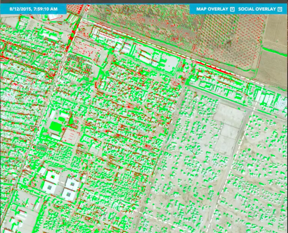 Analysis of Zaatari refugee camp using GBDX and Spaceknow’s Change Detection feature. Imagery ©DigitalGlobe 2016[/caption]
Industrial Facilities in China
[caption id="attachment_4449" align="alignleft" width="400"] A historic first: Spaceknow’s Satellite Manufacturing Index (SMI) on Bloomberg Terminals. Imagery ©Bloomberg 2016[/caption]
Spaceknow created the first-ever Satellite Manufacturing Index (SMI), which went live on Bloomberg Terminals on March 1. The Spaceknow interface closely monitors activity at more than 6,000 industrial facilities across China. Using more than 2.2 billion individual satellite observation points, the SMI index is composed of analysis of an area of 0.5 million square kilometers spanning the last 15 years.
Coming soon, Spaceknow will be using GBDX for our Watchdog service. This will provide customers with a continuous and automated near real-time monitoring of almost any selected location on the planet—from beach houses on the North Carolina coast to Iranian nuclear facilities.
At Spaceknow, we’re in a market of exponential growth with infinite applications of satellite imaging services. I am incredibly excited to be partnered with DigitalGlobe along the way, and hope that together we can continue to make the global economy more transparent for our clients.
Pavel Machalek is co-founder and CEO of Spaceknow Inc.
A historic first: Spaceknow’s Satellite Manufacturing Index (SMI) on Bloomberg Terminals. Imagery ©Bloomberg 2016[/caption]
Spaceknow created the first-ever Satellite Manufacturing Index (SMI), which went live on Bloomberg Terminals on March 1. The Spaceknow interface closely monitors activity at more than 6,000 industrial facilities across China. Using more than 2.2 billion individual satellite observation points, the SMI index is composed of analysis of an area of 0.5 million square kilometers spanning the last 15 years.
Coming soon, Spaceknow will be using GBDX for our Watchdog service. This will provide customers with a continuous and automated near real-time monitoring of almost any selected location on the planet—from beach houses on the North Carolina coast to Iranian nuclear facilities.
At Spaceknow, we’re in a market of exponential growth with infinite applications of satellite imaging services. I am incredibly excited to be partnered with DigitalGlobe along the way, and hope that together we can continue to make the global economy more transparent for our clients.
Pavel Machalek is co-founder and CEO of Spaceknow Inc.