There is a common thread among national security analysts throughout the world: they are looking for every advantage they can find to protect their interests at home and abroad. Maxar, formed SecureWatch to support these analysts with the world’s most powerful geospatial intelligence (GEOINT) service. The SecureWatch team constantly evaluates sources of GEOINT to deliver the most valuable datasets to our global mission partners.
Our latest release of SecureWatch includes an integration of the open source NOAA / NASA Visible Infrared Imaging Radiometer Suite (VIIRS) Nighttime Lights imagery for all subscribers. Nighttime Lights imagery enables analysts to detect human activity while monitoring wide areas because they can quickly spot places where they don’t expect to see human activity or places with more activity than previously known.
By using Nighttime Lights in the SecureWatch platform, which contains Maxar high-resolution satellite imagery, analysts can investigate anomalous sources of the light. By cross-referencing Nighttime Lights against Maxar’s 30 cm imagery, analysts can better understand human activity across wide areas and answer key intelligence questions to enable decision-making with confidence.
What can you see with Nighttime Lights?
The NOAA / NASA Suomi National Polar-orbiting Partnership (Suomi-NPP) satellite captures Nighttime Lights imagery by recording low-light emissions across the whole planet each night and displaying the information as 750 meter resolution gray-scale images. In cloud free areas, an analyst can visualize significant sources of light such as:
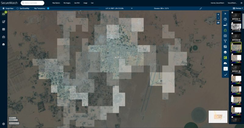
- Built-up areas as small as a village: The image below shows Nighttime Lights overlaid on Maxar imagery taken during daylight, which provides context to the Nighttime Lights imagery.
- Fires: Nighttime Lights provide a base layer of information that easily detects fires. In the SecureWatch platform an analysts can easily create graphics for reports and briefings that call out points of interest in Nighttime Lights using Maxar imagery to get a high-resolution view of activity.
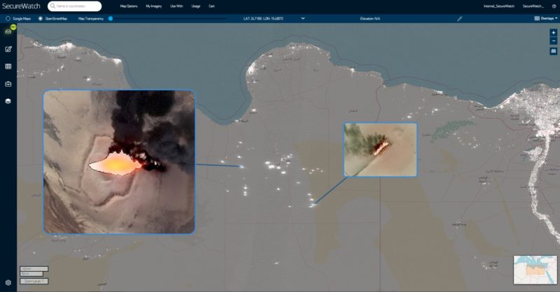
- Individual ships, oil rigs and other vessels on open water: In the GIF below, an analyst detects light coming from the middle of the ocean and references recent Maxar high-resolution imagery to discover the oil rig creating that light.

How does it work?
Maxar harvests and stores Nighttime Lights imagery every night in a secure Amazon Web Services (AWS) Simple Storage Service (S3) bucket; this library dates back to October 2018. As analysts call for the imagery from our web-based interface, SecureWatch pulls the imagery together and automatically stretches the dynamic range for optimal viewing.
The user can create a single or multiple Nighttime Lights layers and visualize them together with map layers and Maxar high-resolution images to study human activity over time and geography, enabling analysts to quickly gather insights into activities happening on the ground to inform their decision-making process.
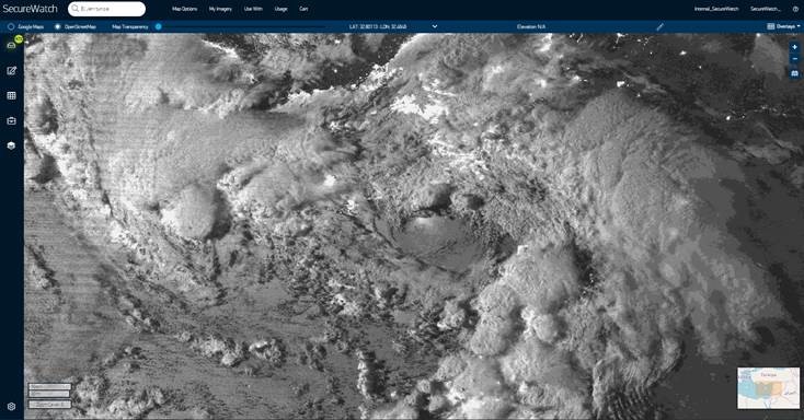
As an added bonus, Nighttime Lights can be strikingly beautiful. In addition to lights, this imagery shows storm systems, like this dramatic one below over the Eastern Mediterranean on Feb. 15, 2019.
To learn more about SecureWatch and request 30 days of free access for your defense or intelligence organization, visit the SecureWatch product page.