- GeoNews. This powerful collection of machine learning models and geospatial algorithms can geolocate news articles from 100+ global sources and stream them live as analysts view imagery. (See below.)
- Human Landscape: Five global Human Landscape layers are available to all SecureWatch subscribers to view overlaid on imagery with more layers available for premium subscription on a countrywide scale. (See below.)
- Open Source GIS Layers: GIS data can be streamed into SecureWatch using numerous Open Geospatial Consortium (OGC) services such as WMS, WMTS and WFS—enabling users to visualize imagery together with both proprietary and publicly available data.
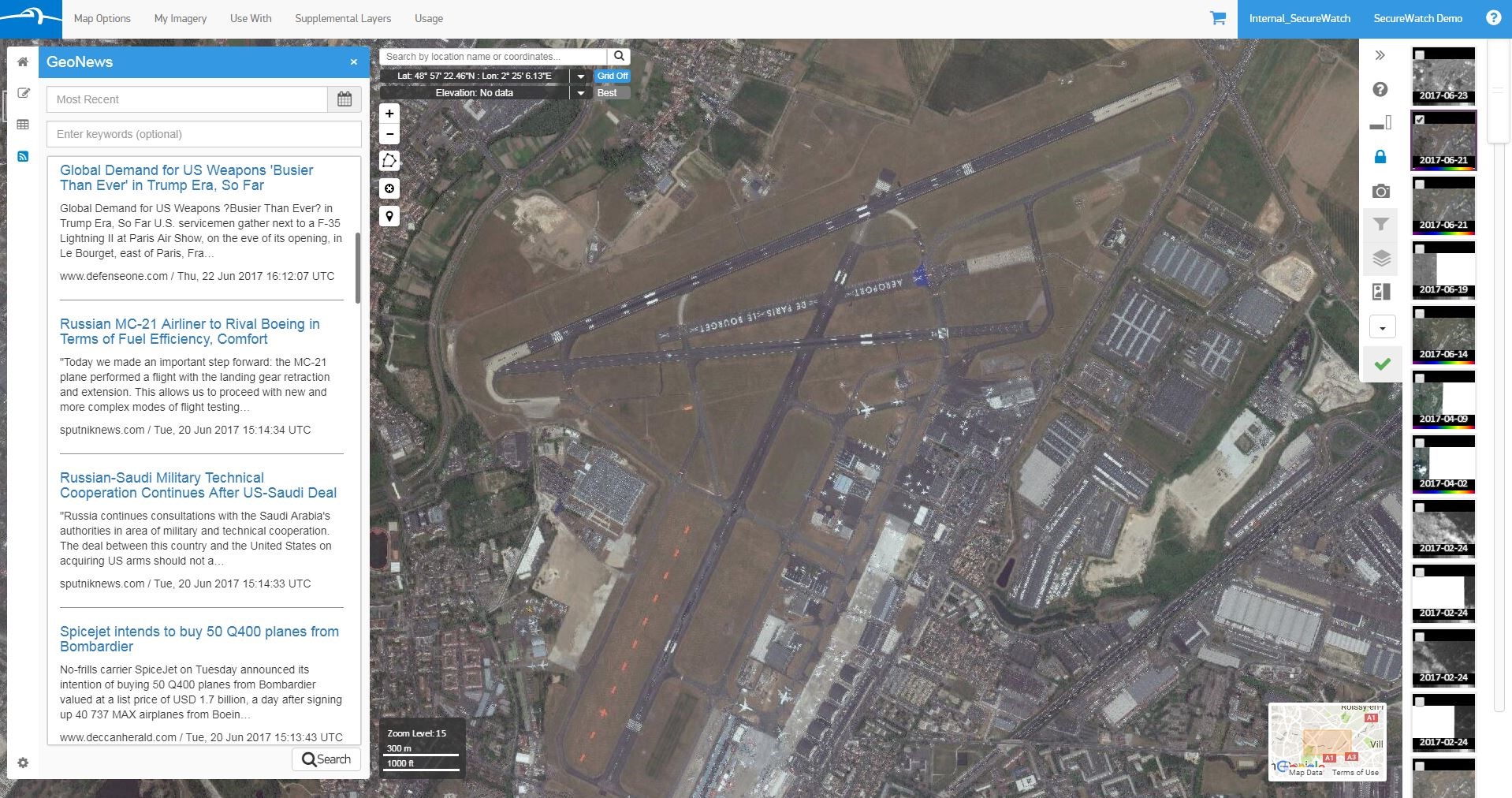 GeoNews streams geo-located news articles into the SecureWatch interface. Coverage of the 2017 Paris Air Show pulled in by GeoNews is shown in the left panel alongside WorldView-3 30 cm imagery of the air show.[/caption]
More about GeoNews
GeoNews combines natural language processing, supervised machine learning and text categorization with a global place gazetteer to create explicit geolocations implied by place names in news stories. These machine learning-derived insights enable analysts to navigate the news interactively using a map view. Instead of manually searching and sifting through hundreds of news feeds, GeoNews provides analysts with a simplified method of maintaining situational awareness about what is happening on the ground anywhere on Earth—to help them focus on higher-value tasks.
[caption id="attachment_6024" align="aligncenter" width="1330"]
GeoNews streams geo-located news articles into the SecureWatch interface. Coverage of the 2017 Paris Air Show pulled in by GeoNews is shown in the left panel alongside WorldView-3 30 cm imagery of the air show.[/caption]
More about GeoNews
GeoNews combines natural language processing, supervised machine learning and text categorization with a global place gazetteer to create explicit geolocations implied by place names in news stories. These machine learning-derived insights enable analysts to navigate the news interactively using a map view. Instead of manually searching and sifting through hundreds of news feeds, GeoNews provides analysts with a simplified method of maintaining situational awareness about what is happening on the ground anywhere on Earth—to help them focus on higher-value tasks.
[caption id="attachment_6024" align="aligncenter" width="1330"]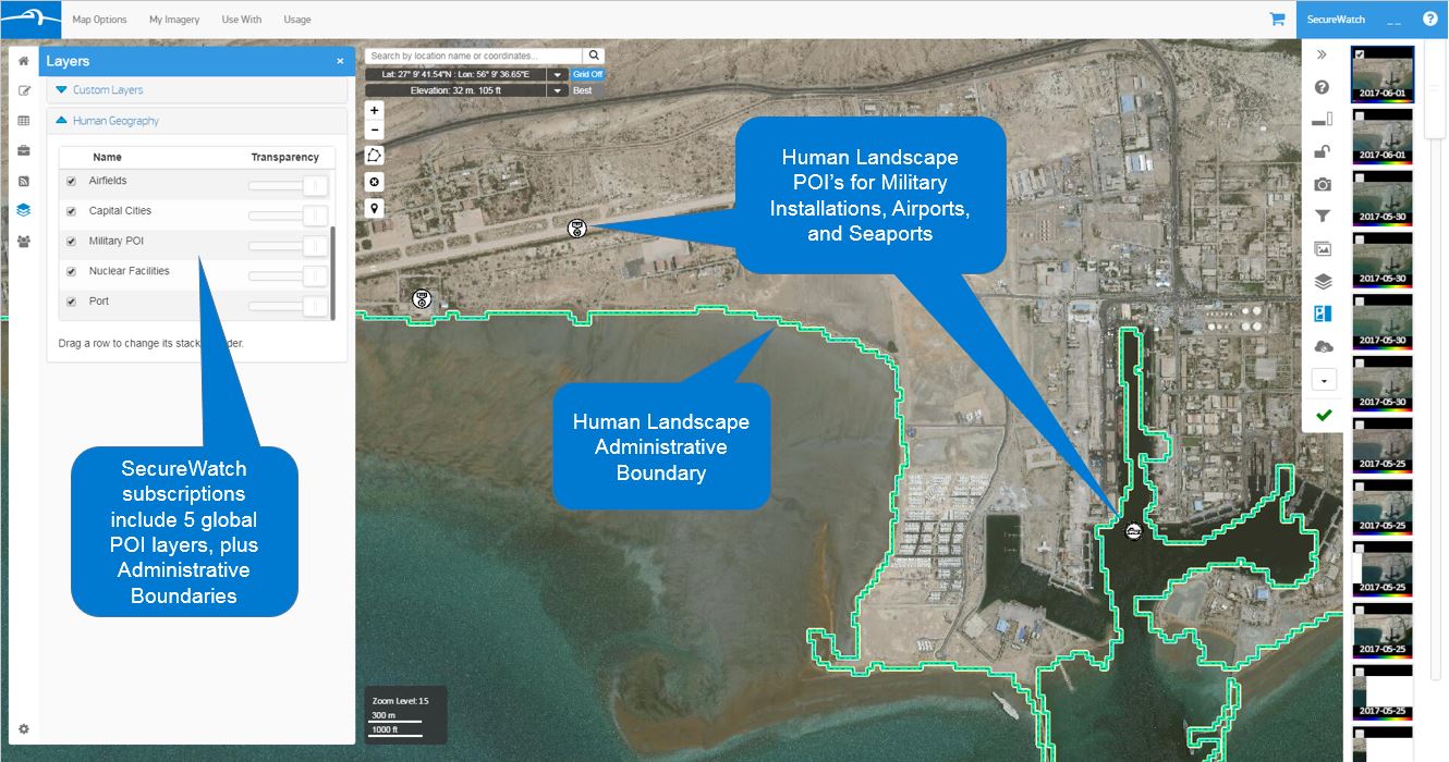 Human Landscape integrates with imagery in SecureWatch to provide insights into human geography. The background is Bandar Abbas, Iran. 30 cm image captured by WorldView-3, June 1, 2017.[/caption]
More about Human Landscape
At DigitalGlobe, our vision is to be the indispensable source of information about our changing planet. In addition to our world-class satellite imagery, we develop and maintain a dynamic Human Landscape database that catalogs millions of points of interest across the globe—providing critical foundational information to give context to imagery and other types of location data. Spanning more than 60 different data layers (e.g., communications infrastructure, transportation hubs, airports, seaports, military bases, medical facilities), our Human Landscape database provides comprehensive data about where things are located all over the world. Other layers provide qualitative data about life in the area of interest—including languages spoken, religions practiced and ethnic groups that live there. This information, combined with high-resolution satellite imagery, enables analysts to produce accurate intelligence deliverables which give leaders the confidence to take decisive action.
SecureWatch is a powerful service for organizations seeking to improve intelligence cycles using the best commercial satellite imagery and rich layers of geospatial intelligence. Find more information and request a free 30-day evaluation subscription at the SecureWatch product page.
Human Landscape integrates with imagery in SecureWatch to provide insights into human geography. The background is Bandar Abbas, Iran. 30 cm image captured by WorldView-3, June 1, 2017.[/caption]
More about Human Landscape
At DigitalGlobe, our vision is to be the indispensable source of information about our changing planet. In addition to our world-class satellite imagery, we develop and maintain a dynamic Human Landscape database that catalogs millions of points of interest across the globe—providing critical foundational information to give context to imagery and other types of location data. Spanning more than 60 different data layers (e.g., communications infrastructure, transportation hubs, airports, seaports, military bases, medical facilities), our Human Landscape database provides comprehensive data about where things are located all over the world. Other layers provide qualitative data about life in the area of interest—including languages spoken, religions practiced and ethnic groups that live there. This information, combined with high-resolution satellite imagery, enables analysts to produce accurate intelligence deliverables which give leaders the confidence to take decisive action.
SecureWatch is a powerful service for organizations seeking to improve intelligence cycles using the best commercial satellite imagery and rich layers of geospatial intelligence. Find more information and request a free 30-day evaluation subscription at the SecureWatch product page.