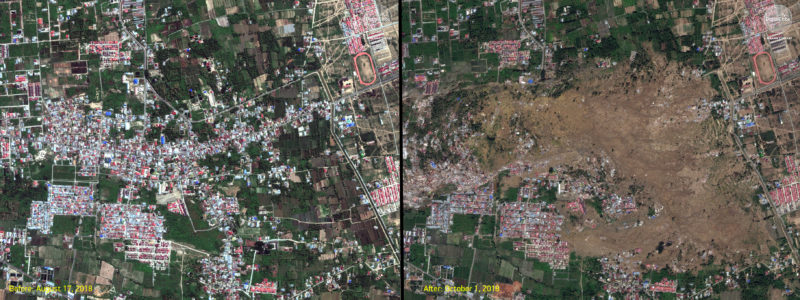
On Friday, September 28th, a devastating 7.5 magnitude earthquake triggered a deadly 10 foot tsunami on the island of Sulawesi in Indonesia. At this time, more than 1,350 people have been confirmed dead, with that number certain to rise as more areas become accessible. The resort town of Palu was hard hit and the lack of equipment is hampering rescue missions. State agencies are struggling to get staff into the areas as the main airport at Palu was damaged, landslides have cut roads and power is out almost everywhere.
When crises like this occur, Maxar is committed to supporting the humanitarian community and fulfilling our purpose of Building a Better World by providing critical and actionable information to assist response efforts. As part of our Open Data Program, we will publicly release data of the affected areas to support disaster response as it becomes available.
Any imagery or data distributed through the Open Data Program is licensed under the Creative Commons Attribution Non-Commercial 4.0 license (CC BY-NC 4.0). This licensing allows for non-commercial use of the information, meaning it can quickly be integrated into first responder workflows with organizations like Team Rubicon, the Red Cross and other non-profits. If commercial companies are interested in using the data distributed through the Open Data Program, it can be purchased by contacting Maxar.
Please continue to check this site and our social media channels for updates on pre- and post-event data.