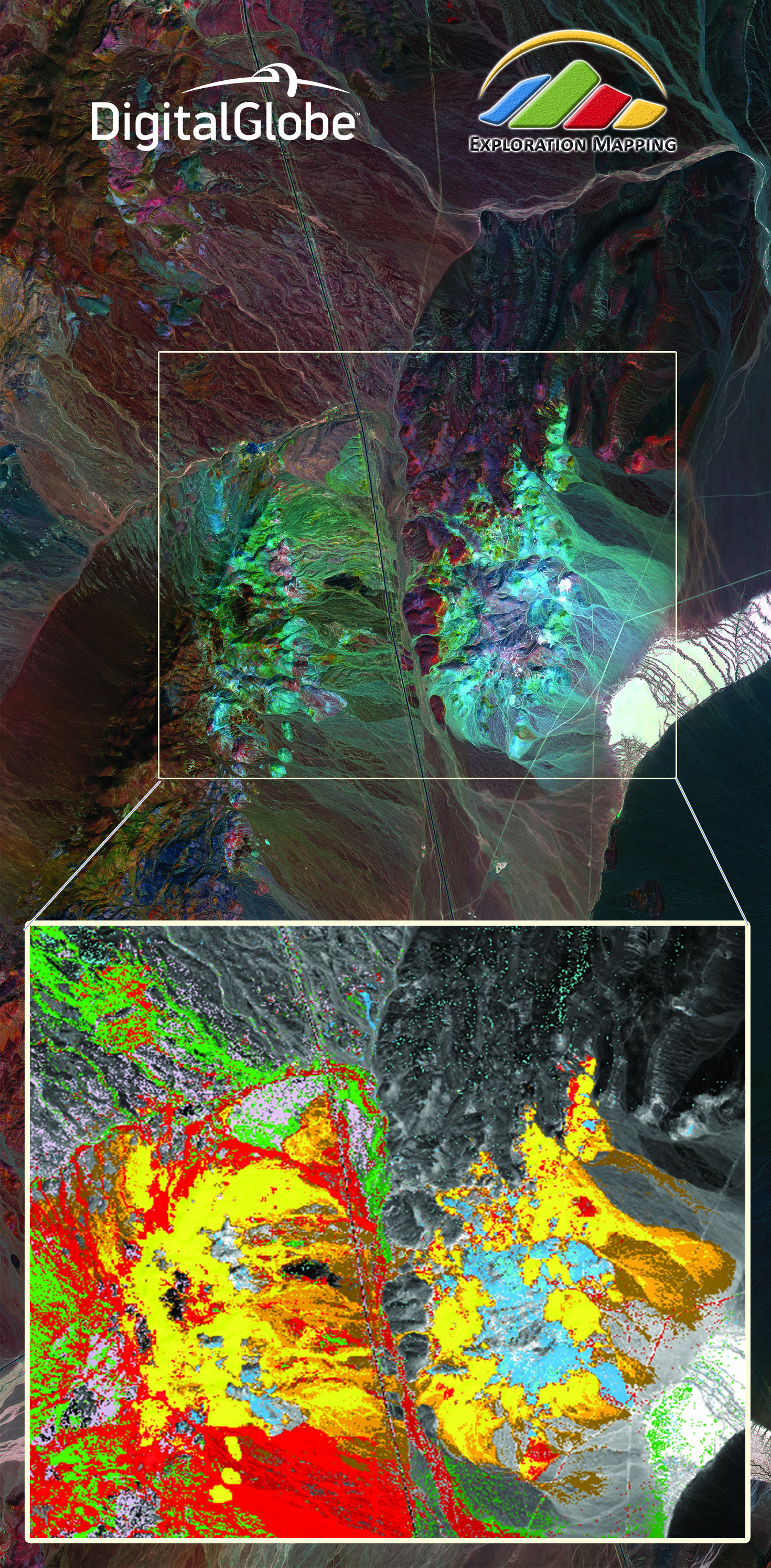
 Cuprite, Nevada is one of the most iconic remote sensing sites in the world and has been used as a calibration test site for every major resource satellite ever flown. The yellow, green and brown colors represent high concentrations of silica, iron and clay alteration minerals and are just a few of the 30+ mapping classes produced by Exploration Mapping Group for resource exploration. This 30cm WorldView-3 image was collected on February 10, 2015. Imagery enhanced by Exploration Mapping Group.[/caption]
“We are excited about the new information partnership with DigitalGlobe to support our customers in the natural resources sector. Access to DigitalGlobe’s Worldview-3 satellite data represents the most significant technological breakthrough in satellite remote sensing since the launch of the ASTER satellite in 1999. DigitalGlobe’s WorldView-3 is the first and only commercial imaging satellite capable of collecting imagery with 30 cm ground sample distance – five times the detail of the company's nearest competitor – and has unprecedented spectral coverage in the regions useful for geological and environmental mapping. Our customers will benefit from our new specialized suite of WorldView-3 image products used for geoscientific mapping, infrastructure planning, environmental characterization and incident response,” said Dan Taranik, Exploration Mapping Group’s Managing Director.
With WorldView-3’s remote sensing capabilities, Exploration Mapping can identify geological features that will have been missed by older satellites. The multi-spectral coverage in the shortwave infrared (SWIR) and visible and near infrared (VNIR) bands provides Taranik and his team with a new capability to identify and map mineral signatures that are key to precious and base-metal ore discoveries including gold, silver, copper and nickel. Similarly, Exploration Mapping’s petroleum exploration information products will benefit from WorldView-3 technology to map geology and minerals key to petroleum discovery based on the multi-spectral signatures of host rocks where oil deposits are located.
“Natural resource companies increasingly explore in remote regions of the world covering hundreds of square kilometers with challenging, inhospitable terrain, poor infrastructure and limited field seasons that are not easily covered using ground-based approaches. Project work often involves days of travel using all-terrain vehicles, horseback, by foot and in some cases helicopter support which carry a variety of heightened health and safety risks. Given the operational challenges, seasonality and expense of exploration, new WorldView-3 imagery will allow our customers to plan and focus their field operations with greater precision than ever before to save time and valuable resources throughout the exploration and development lifecycle,” Taranik said.
To learn more about DigitalGlobe’s Information Partner Program, visit digitalglobe.com/partners/information-partners.
To contact Exploration Mapping Group, email info@explorationmapping.com.
Cuprite, Nevada is one of the most iconic remote sensing sites in the world and has been used as a calibration test site for every major resource satellite ever flown. The yellow, green and brown colors represent high concentrations of silica, iron and clay alteration minerals and are just a few of the 30+ mapping classes produced by Exploration Mapping Group for resource exploration. This 30cm WorldView-3 image was collected on February 10, 2015. Imagery enhanced by Exploration Mapping Group.[/caption]
“We are excited about the new information partnership with DigitalGlobe to support our customers in the natural resources sector. Access to DigitalGlobe’s Worldview-3 satellite data represents the most significant technological breakthrough in satellite remote sensing since the launch of the ASTER satellite in 1999. DigitalGlobe’s WorldView-3 is the first and only commercial imaging satellite capable of collecting imagery with 30 cm ground sample distance – five times the detail of the company's nearest competitor – and has unprecedented spectral coverage in the regions useful for geological and environmental mapping. Our customers will benefit from our new specialized suite of WorldView-3 image products used for geoscientific mapping, infrastructure planning, environmental characterization and incident response,” said Dan Taranik, Exploration Mapping Group’s Managing Director.
With WorldView-3’s remote sensing capabilities, Exploration Mapping can identify geological features that will have been missed by older satellites. The multi-spectral coverage in the shortwave infrared (SWIR) and visible and near infrared (VNIR) bands provides Taranik and his team with a new capability to identify and map mineral signatures that are key to precious and base-metal ore discoveries including gold, silver, copper and nickel. Similarly, Exploration Mapping’s petroleum exploration information products will benefit from WorldView-3 technology to map geology and minerals key to petroleum discovery based on the multi-spectral signatures of host rocks where oil deposits are located.
“Natural resource companies increasingly explore in remote regions of the world covering hundreds of square kilometers with challenging, inhospitable terrain, poor infrastructure and limited field seasons that are not easily covered using ground-based approaches. Project work often involves days of travel using all-terrain vehicles, horseback, by foot and in some cases helicopter support which carry a variety of heightened health and safety risks. Given the operational challenges, seasonality and expense of exploration, new WorldView-3 imagery will allow our customers to plan and focus their field operations with greater precision than ever before to save time and valuable resources throughout the exploration and development lifecycle,” Taranik said.
To learn more about DigitalGlobe’s Information Partner Program, visit digitalglobe.com/partners/information-partners.
To contact Exploration Mapping Group, email info@explorationmapping.com.