African elephants are at risk in the majority of the countries where they live because of poaching. Elephants are killed in retaliation for crop raiding or for ivory, which is highly lucrative in Asian markets. The human population in Africa is rapidly increasing and as a result, more elephant habitat is being used for agricultural production and human settlement. The areas where elephants can freely roam are diminishing, and human-wildlife conflict is on the rise. There are several techniques used to deter elephants from entering cropland and human-inhabited areas, including the use of chili fences/bombs, bee fences and technological solutions designed as early warning systems to communities.
To plan long-term sustainable solutions to the stresses elephants are experiencing, it is necessary to have accurate data on elephant numbers and their geographical range to identify high-risk areas. There are several methods used to conduct elephant surveys, including line transect surveys, dung and track counts, aerial surveys and camera trap surveys. One under-explored area of research is the use of high-resolution satellite imagery to monitor herds.
[caption id="" align="aligncenter" width="617"]

Elephants in Addo Elephant National Park, South Africa. Image acquired by WorldView-4 on January 12, .2014.[/caption]
[caption id="" align="aligncenter" width="780"]
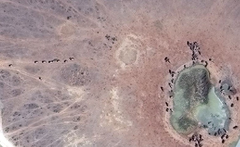
Elephants aggregated around and walking to a water hole in Addo Elephant National Park, South Africa. Image acquired by Worldview-4 on October 2, 2016.[/caption]
DigitalGlobe’s WorldView-3 and WorldView-4 satellites provide multispectral imagery at 30 cm resolution after pan-sharpening. In clear weather conditions, elephants can be identified visually by viewing the imagery. However, the challenge with this technique is locating herds, which travel on average 25 km per day. And when running, elephants can reach speeds up to 60 km. Without location data, it would take hours to screen images at full zoom to detect herds; a fully grown bull elephant shows up in less than 15 pixels on a WorldView-3 or WorldView-4 image.
[caption id="" align="aligncenter" width="656"]
An African Bull Elephant comprises approximately 15-20 pixels in WorldView-3 and WorldView-4 satellite images as shown above.[/caption]
[caption id="" align="aligncenter" width="800"]
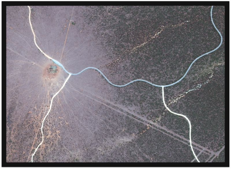
WorldView-4 image acquired on the January 29, 2016 of Addo Elephant National Park, South Africa.[/caption]
To overcome this time- and labor-intensive challenge and to make satellite image surveys a scalable monitoring method, we are developing a convolutional neural network (CNN), an algorithm that will automate the detection of herds in satellite images. To create the training data for the algorithm, we used GPS data from herds in the Kavango Zambezi Transfrontier Conservation Area in Sub-Saharan Africa that were wearing collars provided by Elephants without Borders. The GPS data was cross-referenced with coordinates of images from the WorldView-3 and WorldView-4 imagery library to show the algorithm exact examples of what elephants look like from space. Additionally, training data was collected from Addo Elephant National Park in South Africa where there is a high concentration of elephants in a relatively small area. After labelling satellite images by drawing bounding boxes around individual elephants and non-elephant objects in the landscape (e.g., trees), machine learning (ML) was applied via a CNN to teach the machine the difference.
[caption id="" align="aligncenter" width="681"]

Elephant training data labelled using LabelImg GUI in Python .[/caption]
[caption id="" align="aligncenter" width="582"]
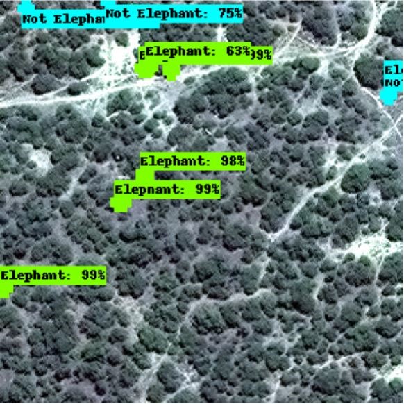
Initial test data results after 10,000 iterations using Tensorflow API and the Red, Blue, Green and Near-Infrared image bands (NIR).[/caption]
Once the algorithm has been fully tested, it will be applied to wild populations in images without requiring GPS-collar positions. The potential for artificial intelligence (AI) and machine learning to be applied to novel wildlife challenges is great. There are already a number of CNNs that are more accurate than human detection in some challenging image classification and object detection areas. With enough training data, CNNs have the ability to learn complex, distinctive features of objects in short time periods and assign objects to predefined categories with the same or even higher accuracy compared with human detection. Results from this study will be published later this year so other researchers can build on the results. This monitoring technique is likely to be widely used in the future to monitor elephants, particularly as the resolution of satellite imagery increases and the AI/ML field advances. Developing a close to real-time monitoring technique will allow herds to be tracked more effectively, enabling more effective conservation planning and management.
DigitalGlobe, a Maxar Technologies company, supports the use of imagery for research and educational purposes fulfilling Maxar’s purpose of Building a Better World.