In my last blog, I described the combination with MDA as the “go fast” button for the DigitalGlobe that will allow us to accelerate toward our vision. But there’s another kind of “go fast” in our business, which is about how quickly we can get actionable information in the hands of our customers and end users. I’d like to share how we do that today, and where we’re going in the future.
DigitalGlobe is best known for its satellites, which collect the data that give our customers a unique ability to understand our changing planet, whether it’s the activity of a single oil derrick, crop conditions across an entire region, or the changing volume of traffic at all of the world’s airports and seaports. But satellites are just the tip of the iceberg as it relates to our end-to-end value chain. Beneath the surface, there’s an incredible amount of infrastructure and expertise being leveraged around the clock to deliver the right information to the right customer at the right time.
[twenty20 img1="5310" img2="5311" offset="0.5"]
Port-à-Piment, Haiti, before Hurricane Matthew (left) and after (right).
Real-time crisis & event response
In October 2016, Hurricane Matthew wreaked havoc across the Caribbean and eastern United States. An estimated 1,600 lives were lost, and damages have been estimated at $10.5 billion. Haiti was hit especially hard, as the hurricane and severe flooding left 1.4 million people in need of humanitarian aid.
When large-scale crises occur, DigitalGlobe is committed to supporting the humanitarian community by providing timely, critical information to assist response efforts, as recently codified in our Open Data Program for disaster response. For Hurricane Matthew, within hours after our satellites passed over the island nation we released pre- and post-event imagery and the results of our Tomnod crowdsourcing campaign to pinpoint the damaged and flooded areas. The imagery and information extracted from it was used by organizations on the ground including the United Nations, the Red Cross, and the Haitian Government.
Leveraging imagery, cloud computing, and machine learning algorithms can accelerate disaster response further still. Using AnswerFactory powered by DigitalGlobe’s GBDX, water can be automatically extracted with our proprietary Protogen algorithm, which we used to assess water levels at Lake Oroville in California following a series of heavy rainstorms in February.
[caption id="attachment_5347" align="aligncenter" width="1022"]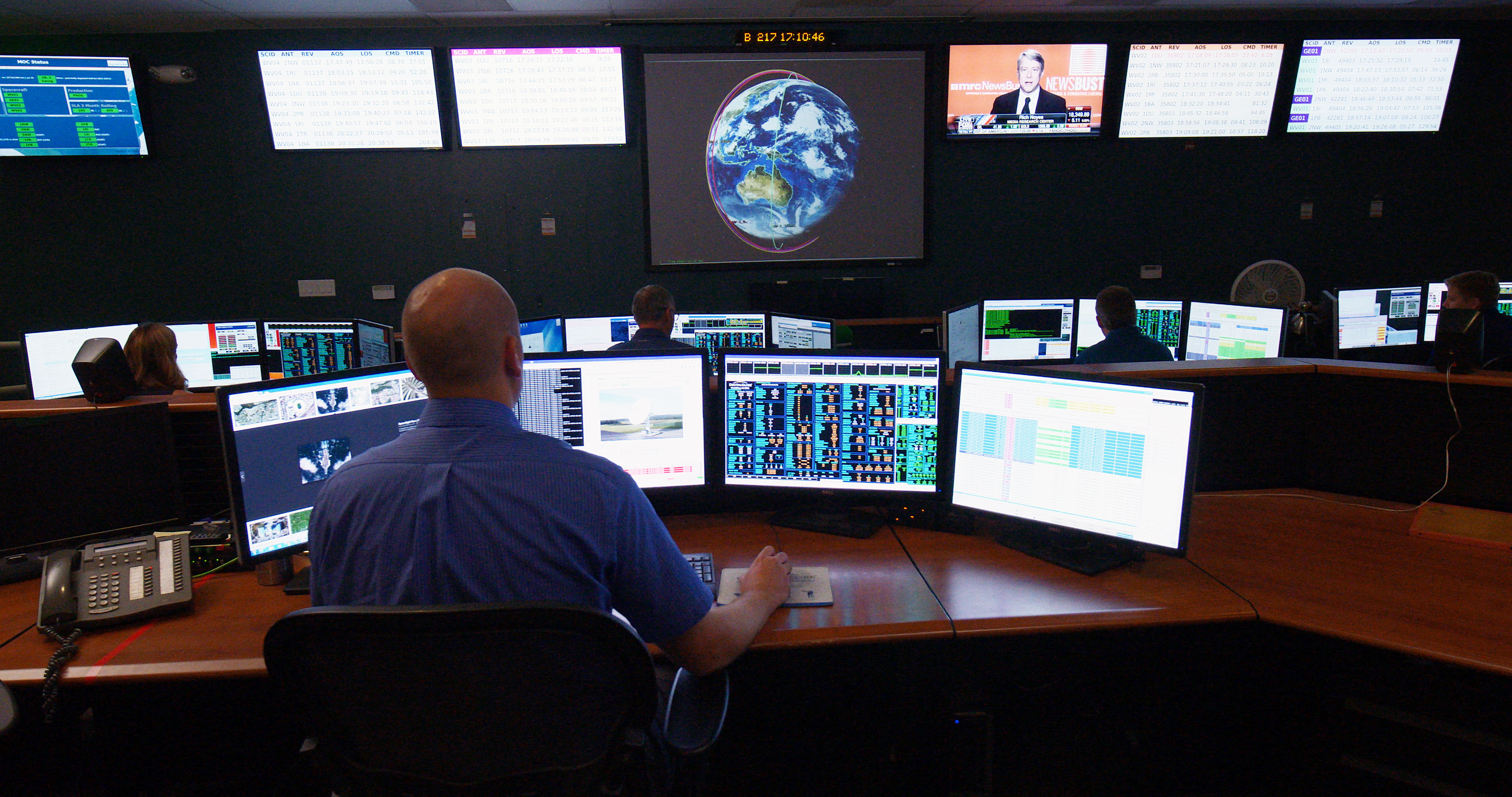 DigitalGlobe’s Mission Operations Center, where our constellation is controlled by
highly trained satellite operators 24/7/365.[/caption]
Purpose-built infrastructure, vigilance, and experience – getting critical information to users in as little as 12 minutes.
Our purpose-built technology infrastructure, vigilance, and experience enabled us to provide the timely, accurate information that allowed response and recovery teams to make decisions with confidence. Teams of four highly trained satellite operators in our Mission Operations Center—supported by highly automated systems—work 24/7/365 to keep our satellite constellation in perfect working order—achieving a 99.75% satellite availability, while fulfilling thousands of tasking requests every day.
Hurricanes come with advanced warning. For less predictable events like earthquakes, oil spills, political protests, or plane crashes, we rely on a multitude of proprietary and open-source tools, such as the Global Disaster Alert and Coordination System, to become aware of events that our customers will be interested in—often before they’re widely known. Our automated scheduling system continuously updates the tasking plan for our satellites, allowing us to send updates to a satellite just minutes before an image is collected. This system lets us collect over 2,400 images per day, comprising 3 to 4 million square kilometers of high-resolution imagery of the places that are relevant, adding a whopping 70 terabytes each day to our 100-petabyte image library.
To make this possible, DigitalGlobe operates a global network of Remote Ground Terminals (RGTs), consisting of antennas and equipment for securely communicating with our satellites. A single RGT can communicate with a satellite whenever they have a direct line of sight, even at distances of several thousand miles. Our global RGT network gives us real-time contact with our satellites when they are in view of about 45% of the land mass of the planet (and a much higher percentage of the “interesting” places), and our satellites are never more than 20 minutes away from the next opportunity to beam back freshly collected imagery. These image files are enormous, with a satellite like WorldView-3 able to image an area the size of Belgium—170 gigabytes of high-resolution data—in just a few minutes. Fortunately, the satellite downlinks data at 1.2 gigabits per second from several thousand miles away, comparable to the speed of a latest-generation (802.11ac) wi-fi router, but at something like 40,000 times the distance!
Once the imagery has been received at an RGT, it is blasted back to our headquarters, either over the Internet or via a dedicated satellite link, where it is decrypted, processed, and made available for delivery. That delivery can be via direct download, via web platforms like Global EGD and My DigitalGlobe, or hosted in the cloud for analytic processing via our Geospatial Big Data platform (GBDX).
Images are available in as little as a dozen minutes after collection, and almost always under 2 hours. This happens day in, day out, not just for a single image but for the thousands of images that DigitalGlobe collects every day. This is one of the key advantages of satellites over airborne collection platforms: while airborne platforms can be more-or-less anywhere (if they happen to already be in the area), our satellites can be both anywhere and everywhere, since they collectively circle the globe 75 times each day.
With satellites in both morning and afternoon orbits, today’s DigitalGlobe constellation can see any place on the surface of the Earth an average of 6 times daily, imaging some of them as early as 9 a.m. and some as late as 3 p.m. local time. This matters because the global events that our customers are interested in are highly dynamic, with conditions that change throughout the day.
Next-generation capabilities will deliver up to 3X the capacity, with industry-leading resolution & revisit — all available in the cloud.
But we’re not content to be at the leading edge of the industry today. We’re taking the DigitalGlobe to the next level, doubling down on speed, capacity, and quality. We can now offer our customers access to broad-imagery from Landsat and high-resolution electro-optical and radar satellite imagery from multiple commercial providers. These data sources give our customers an unprecedented ability to monitor areas of high interest, especially when combined with our proprietary tools for mining and geolocating media and social media content. Incidentally, partnering with DigitalGlobe in this way gives emerging satellite providers access to the world’s largest users of geospatial information without making large investments in ground infrastructure, processing and enrichment expertise, and global sales channels.
When our next-generation WorldView Legion constellation and Scout small satellite constellations are in service in 2020, we’ll be able to revisit the most rapidly changing areas on Earth as frequently as every 20 to 30 minutes, from sunup to sundown, to enable entirely new use cases and near-real time change detection. WorldView Legion will also double our capacity to collect 30 cm and multi-spectral imagery, and nearly triple our overall capacity over high-demand areas. And as with our existing constellation, we’re pushing all of it to the cloud, where users can tap into our ecosystem and leverage the most advanced processing and analytic tools to unlock the answers faster than ever. These capabilities will provide even greater insights into global events of significance, giving our customers the ability to make critical decisions with confidence when time is of the essence.