The Democratic Republic of the Congo declared an outbreak of the Ebola virus in Equateur Province on May 8, 2018. Despite proactive containment efforts, the response on the ground struggled due to a lack of information about the affected communities. A report in The Atlantic noted that almost all the existing maps of the outbreak zones contained inaccuracies, and that different health organizations were operating from disparate maps and sources of information. Through DigitalGlobe's Open Data Program, we publicly released two current building footprint datasets, a roads dataset and a human landscape geodatabase, to support the containment efforts and build their health surveillance system going forward. Fortunately, the last Ebola case there was diagnosed more than a month ago, and the outbreak is now believed to be over.
To fulfill DigitalGlobe's Purpose of Seeing a Better World, we use our unique capabilities to contribute to humanitarian and environmental causes and enhance global transparency. The Open Data Program is one of many ways DigitalGlobe leverages its technology and data to make the world a better place. Just in the last year, we’ve contributed vital data that has supported successful response and recover efforts for wildfires in California, monsoons in Asia, hurricanes in the Caribbean, earthquakes in Mexico and more.
Our parent company, Maxar Technologies, operates a program called the Maxar News Bureau that provides access to the company’s technology to help trusted media organizations report on stories around the globe. As part of this initiative, DigitalGlobe supplies high-resolution satellite imagery and analysis to support news reporting. While enabling the Associated Press’ Pulitzer Prize-winning Seafood from Slaves investigation is our most well-known project, in the past year we’ve also shined a light on the plight of the Rohingya muslims in Bangladesh, the path of destruction left by the Islamic State, and the impacts of natural disasters on communities around the world.
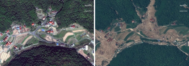 The Maxar News Bureau released imagery from DigitalGlobe’s WorldView-3 satellite demonstrating the impacts of flooding and landslides in Japan last week. The images above are of an areas south of Enshoji, Japan. The image on the left was taken Oct. 26, 2017 and the image on the right was taken on July 10, 2018.
DigitalGlobe also donates imagery and geospatial analytics to three organizations that share our commitment to Seeing a Better World. The Jane Goodall Institute uses DigitalGlobe imagery and analytics to make conservation decisions based on changes to chimpanzee habitats and how land is used near those areas. The Amazon Conservation Team monitors South American rainforests with imagery to help protect indigenous communities and implement conservation strategies. And Team Rubicon is a veteran’s organization that uses DigitalGlobe imagery and analytics to plan disaster response missions.
We are proud to contribute to the well-being of our planet and its people. But this work is only made possible by the success we’ve had in building a strong imagery business that now generates more than $800 million a year. Government and commercial customers rely on us to provide a source of geospatial truth and timely insight for a wide variety of projects, many of which are making valuable contributions to society in their own right:
- Dating back to 2003, our relationships with the U.S. government and foreign friendly governments have provided a large part of our revenue. We play key roles in supporting their missions, and we have partnered with them to further innovate and develop our offerings.
- Technology companies like Google utilize DigitalGlobe’s imagery as a foundational map layer and a source of extracted features like roads, buildings and landforms.
- Energy companies use imagery and analytics to monitor infrastructure, including changes onshore and offshore, to respond quickly for repairs. They also use our data to monitor encroachment of pipelines.
- Automobile manufacturers and their suppliers employ DigitalGlobe data on citywide, nationwide and global scales to keep their smart vehicles operating safely. Companies that operate large fleets of vehicles can use the same data to optimize their routes.
- Insurance companies rely on our incredibly accurate building footprints to map assets to enable better underwriting as well as claims assessment after a disaster.
- Telecommunications companies leverage our imagery and derived elevation products to analyze signal propagation for 5G networks and wireless internet services.
- Civil Governments trust our data to monitor road and infrastructure construction and use it to inform city planning.
DigitalGlobe’s data and technology makes us the industry leader in commercial satellite imagery and a partner to many of the world’s largest organizations. Their trust in us and our business model empowers us to give back to society in a meaningful way. Team members are motivated by our Purpose, which makes DigitalGlobe a truly unique organization — one that I am incredibly humbled and proud to lead.
To learn more about what makes DigitalGlobe tick, read DigitalGlobe Founder and Maxar CTO Dr. Walter Scott’s blog, Success in Commercial Remote Sensing.