At DigitalGlobe we spend a great deal of time focused on urban areas, where the majority of the world’s people now live, and thus where the majority of commerce, conflict, and change take place. Earlier this year an interesting thought crossed my mind: “What would a perfect city look like from space?” Would it have large open venues or lots of public transportation? Would there be an abundance of parks or the tallest skyscrapers in the world? How would this vision of idyllic urban design change depending on where in the world you were?
Since I spend my days at DigitalGlobe working to bring cutting-edge analytics to our GBDX platform, I naturally wondered if we could apply machine learning to our satellite imagery to explore this idea. Specifically, I wanted to find out if we could train a neural network to predict human characteristics of a city simply by looking at DigitalGlobe imagery, an approach that will ultimately help our customers plan for tomorrow’s changing world and make decisions with confidence.
To explore this further we reached out to our friends over at Stamen Design and Carnegie Mellon. Together we created “Penny,” an AI in the sky that predicts median income from space. Penny is an implementation of ResNet-50, a deep convolutional neural network, trained on DigitalGlobe high-resolution satellite imagery and census block data. Penny has learned to associate patterns it sees in our imagery with human patterns of wealth in two cities, St. Louis and New York City.
But the real fun in Penny is the ability to manipulate satellite imagery to try and raise or lower the predicted wealth in an area. You can move the Empire State Building to the Bronx and see how it changes Penny’s predictions. Maybe you’re interested in a home in a St. Louis suburb with the Gateway Arch in your backyard. Penny will predict the median income of this hypothetical new neighborhood. But I should note that we created Penny as an experimental tool for experiencing machine learning, and you probably shouldn’t rely on its results to decide whether the major landscaping project you’re considering is a good investment.
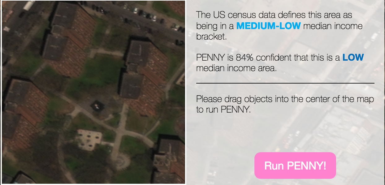
Let’s look at a real example in East Harlem. For this project we split income into low, medium-low, medium-high and high quartiles. In this area, the U.S. Census tells us this is a medium-low median income level, and Penny actually thinks it’s a low-median income area. To test the impact of trees on Penny’s perception of wealth in this area, I filled the entire area around the buildings with trees from Central Park. You can see this has changed Penny’s prediction from low to medium-high. Penny thinks these buildings surrounded by lush trees are more likely to be found in a higher income neighborhood.

The more you play with Penny, the more you discover. And the results can be counterintuitive. Adding trees to a low-income area may cause Penny to reclassify an area into a higher income bracket—but not always. The outcomes are deeply complex with a high degree of spatial variability.
Penny is as powerful as it is playful. It is a tool for exploring our world through a new lens by combining the power of DigitalGlobe’s imagery and the GBDX platform to understand patterns of human activity from space and solve problems more quickly and efficiently than traditional methods.
I hope that you enjoy exploring with Penny as much as we did creating it. Be sure to share with us your discoveries or ideas for what Penny should look for next at Penny@digitalglobe.com