Blog

Editor’s note: Consilium Technology was a finalist for the Grape Growing Category in Australia’s 2018 National Wine Industry Impact Awards. Consilium Technology’s intelligent crop mapping and monitoring product, GAIA, was recognized for excellence because of its revolutionary impact on the wine industry. GAIA leverages Maxar Technologies’ DigitalGlobe imagery and Geospatial Big Data (GBDX) platform to provide actionable insights to the viticulture industry. This blog post dives into the solution that was a finalist for this prestigious Australian award. Technology continues to evolve at a rapid pace. Although this change can be feared, it also presents an incredible opportunity to challenge the status quo and identify new ways to improve. Organizations that embrace this opportunity can use it as a catalyst to thrive in their given industries. Our team at Consilium Technology recently helped the viticulture industry harness the convergence of three exponentially improving technologies:
  1. Machine learning,
  2. Cloud computing, and
  3. Multispectral, high-resolution satellite imagery.

Viticulture Presents an Opportunity

Many decisions for viticulture regulatory authorities stem from one fundamental question: Where are all of the nation’s vineyards located? The seemingly innocent question has important implications for:
  1. Regulating wine labeling requirements based on where the grapes are grown,
  2. Monitoring pest and disease at a national scale, and
  3. Understanding market trends to maximize investment and prevent oversupply.
Previous efforts to answer this question typically involved administering surveys to grape growers, usually on an annual or biennial basis. In addition to being an expensive undertaking, low response rates limited the accuracy of this method. As a result, broad assumptions were made to produce nationwide statistics. With traditional survey methods becoming increasingly prohibitive, the industry sought a new solution. Initial attempts to disrupt the viticulture industry generally involved the use of drone and/or aircraft technologies. Although these methods collected vineyard data more objectively, they had limited repeatability and were not feasible at a continent level. To truly disrupt the industry, a scalable and cost-efficient approach was required. Our team recognized that the inherent limitations of these previous approaches could be overcome by using DigitalGlobe’s high-resolution satellite imagery and GBDX platform. With a strong commitment to remaining abreast of technological advances, we understood that combining the satellite imagery with other exponentially increasing technologies would revolutionize the viticulture industry. It was at this moment, when DigitalGlobe’s satellite imagery was combined with machine learning and cloud computing, that GAIA was born. [caption id="" align="aligncenter" width="800"] 
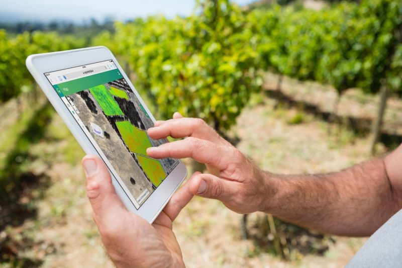
GAIA provides automated and intelligent crop mapping, analytics, and health monitoring at a continent-scale.[/caption]

GAIA – The Greek Goddess of Nature

Aptly named after the Greek Goddess of Nature, GAIA’s core mission is to provide ubiquitous geospatial insight to every grower in every season. GAIA is a web application that delivers continent-scale crop mapping to regulatory organisations, as well as crop health monitoring to growers. GAIA’s ability to automatically map and monitor vineyard rows at a national, and soon to be global, scale is enabled by DigitalGlobe’s 100-petabyte imagery library. This has provided GAIA with plenty of training data to learn what a vineyard looks like, and what a vineyard does not look like – a key requirement for successfully training any machine learning algorithm. As a scalable solution, GAIA is already transforming how the viticulture industry collects vineyard data. For instance, GAIA will conduct Wine Australia’s National Scan for the next three years (2019-2021). This involves accurately mapping Australia’s 65 wine regions to provide information on: 1. The geolocation of every vineyard block in Australia, 2. The vineyard area for each geographical indication, and 3. The vineyard row length for each region. Furthermore, DigitalGlobe’s 18-year-old imagery library makes it possible for GAIA to verify previous survey results and update any data gaps. As a technology-based solution, GAIA improves the accuracy and timeliness of viticulture data analysis, while removing the reporting burden from growers. The multispectral satellite imagery will also enable GAIA to provide growers with valuable insights, such as changes in the health of their vine rows. The ability to objectively monitor vineyard health throughout the growing season will help growers make decisions with confidence. GAIA is able to provide growers with regular updates because DigitalGlobe’s satellite constellation routinely collects new imagery. By integrating this data with existing information systems, GAIA will support growers to adopt increasingly sophisticated precision agriculture techniques – in turn, creating a new realm of promising possibilities.

Embracing the Disruption

The convergence of recent technological developments, coupled with the opportunity to revolutionize existing approaches, has enabled GAIA to disrupt the viticulture industry. As technology continues to advance, it is inevitable that all industries will be disrupted on some level. It is only when we embrace this change, and use it as a catalyst to challenge our current ways of thinking, that we discover and create new opportunities to thrive in our given industries. To learn more about how GAIA is disrupting the viticulture industry, visit: https://projectgaia.ai/
Prev Post Back to Blog Next Post