There is a lot of hype around opening up access to commercial satellite imagery, particularly when it comes to global development initiatives. But when it comes down to it, there is still a huge gap between those of us in the technology world and the communities we seek to benefit. These communities are often far removed from actually using geospatial information in their everyday lives, due to factors like lacking access to technology (computers and data networks), technical capability and awareness of available data. As a result, they tend to distrust information coming from outside sources and are reticent to adopt recommendations from outside groups.Truly ubiquitous satellite imagery means empowering communities to produce, analyze and leverage their own information products. The generation and ownership of the data is directly tied to the community. In that sense, there are many ways in which Maxar partners with global development organizations to empower communities through participatory mapping. One such initiative is Ramani Huria.Ramani Huria, which means Open Map in Swahili, is composed of a broad consortium, consisting of the Tanzania Commission for Science and Technology, the University of Dar es Salaam, Ardhi University, Dar es Salaam City Council, Buni Innovation Hub, supported by the Humanitarian OpenStreetMap Team (HOT), the World Bank, GFDRR and Red Cross. Ramani Huria is focused on mapping the flood prone neighborhoods of Dar es Salaam.
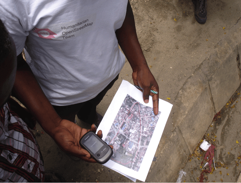
Ramani Huria is unlocking the potential of Maxar’s satellite imagery, alongside many other data inputs, to communities by teaching them how to create highly sophisticated and highly accurate maps of Dar es Salaam, the largest city in Tanzania and the fastest growing city in Africa. From neighborhood to neighborhood, communities are producing these maps to support flood resiliency efforts. Rather than pay for expensive, static flood models, this project helps communities map residential areas, roads, streams, floodplains, and other relevant features, then combines these data with other inputs in software to run realistic natural disaster scenarios for improved disaster preparedness planning and response plans. Participants not only learn valuable computer and mapping skills; they also have a stake in the community’s efforts to become more resilient in the face of continued seasonal flooding.Beyond flood resiliency, these maps have realized huge value for communities in other ways. Last August, Dar es Salaam experienced a rare cholera outbreak. In Tandale, one of the communities hit hardest by the outbreak, neighborhood leaders immediately started using the maps created by Ramani Huria to identify water and sanitation infrastructure within the area, allowing local government to investigate possible sources. In another use case, these maps are supporting the creation of real-time transportation apps, so communities know exactly when the next dala dala, or bus, will pass by next.
Ramani Huria is the future of mapping for development. It is an example of communities producing critical information using a combination of data sources from satellite imagery to drones to GPS devices. Together, community members and university students learn how to produce a field map, how to collect GPS coordinates, how to create vector layers in OSM and much more. It is high tech meets traditional mapping in a beautiful combination of cutting edge tactics and local ownership. Ramani Huria is helping to create the next generation of Tanzanian geospatial experts. This is the real democratization of satellite imagery, enabling communities to derive useful information themselves to fit their needs.
Learn more about Ramani Huria here. Deogratias Minja is a Technical Consultant at the World Bank. Innocent Maholi is Lead Mapping Supervisor at Humanitarian OpenStreetMap (HOT).