Note from DigitalGlobe: Congratulations to one of our finalist teams, Duke University and World Resources Institute, for their solution “Using high-resolution satellite imagery and computer vision to build an open database of global power plants." Learn more about their work below.
We gave five teams access to our Geospatial Big Data platform (GBDX) and 100 PB imagery library to develop a machine learning solution for one of the United Nations’ Sustainable Development Goals. The teams will have the opportunity to showcase their work at a World Bank-hosted event in Washington, D.C.
The power sector is the single largest contributor to global carbon dioxide emissions, contributing over 40%. Meanwhile, one in five people around the world still lacks access to modern electricity. So, when it comes to ensuring access to affordable, reliable, sustainable, and modern energy for all (UN Sustainable Development Goal 7), humanity faces a daunting challenge. The path forward would be clearer if decision makers had better data. In much of the world, power plants and grid lines are well-documented, but that’s not true for many regions facing energy access challenges. And—even in resources like the World Resources Institute’s Global Power Plant Database—information about renewable energy infrastructure is lacking. That’s where we come in. Using high-resolution satellite imagery from DigitalGlobe and the GBDX platform, our team of researchers from Duke University’s Energy Initiative and Applied Machine Learning Lab and the World Resources Institute partnered to demonstrate how using high-resolution satellite imagery coupled with state-of-the-art computer vision techniques can be used to identify and track changes in key energy infrastructure. Specifically, our project targeted the challenge of locating and assessing solar power generation.How it works
Our machine learning techniques automatically identify rooftop solar photovoltaic (PV) arrays in high-resolution satellite imagery using deep learning algorithms—specifically, convolutional neural networks. We can use data gathered from more information-rich regions, like some areas of the United States, to train algorithms that can be applied globally. Maximizing the GBDX platform's rapid data acquisition and analysis capabilities, our team analyzed very high resolution DigitalGlobe satellite imagery from four regions with diverse geographies. This presented us with a unique opportunity to apply our techniques to a much wider array of imagery, helping us overcome the numerous challenges associated with adapting these techniques to new geographic regions. Below are a few examples of our algorithm's capabilities using DigitalGlobe's data and the GBDX platform from diverse locations including Connecticut, Honolulu, India, and China. In India, this information may be used for monitoring solar development and may inform pathways toward access to electricity for villages. Dezhou has been described as China's "Solar Valley" and significant growth in rooftop solar is visible throughout the city on both commercial and residential buildings.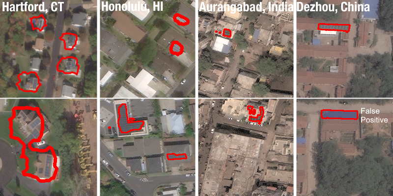 While the algorithm was trained in California (where it performs best), we can adapt it for applications in other locations including the four locations above. However, adapting to new geographies is challenging and may lead to more missed detections and false positives. In this case, the , while the examples from Connecticut proved more challenging. Accurate annotations enable us to estimate capacity (in Watts) and energy generation (in Watt-hours) from satellite imagery.
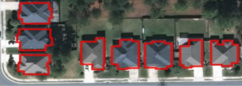
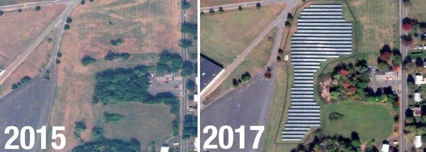
Time-lapse solar development in Connecticut
Satellite imagery is particularly useful for tracking the rapid growth of solar PV over time when the imagery is frequently updated. DigitalGlobe’s five industry-leading satellites regularly update imagery around the world, making the company’s data a key tool in tracking the fast-changing landscape of renewable energy infrastructure. This enables decision makers to plan ahead, ensuring smooth integration of this variable energy source into the grid and understanding what motivates individuals to install solar arrays. The images below show the growth of solar photovoltaic arrays from 2016 to 2017 in Hartford, Connecticut.
Beyond solar arrays
Solar arrays aren’t the only energy infrastructure that can be seen in DigitalGlobe’s imagery that our techniques can map. These techniques can yield plenty of other valuable information for decision-makers seeking to simultaneously ensure universal energy access and environmental sustainability: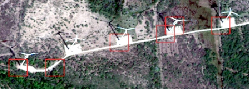 Power plant identification and monitoring. Track the deployment of renewables at all scales, small and large, and characterize key plant properties such as capacity and (for fossil plants) emissions. In the image above, you can see our algorithm identifying wind turbines in (Oaxaca, Mexico).
 Building energy consumption. Use building attributes to estimate energy consumption for identifying opportunities for increasing energy efficiency.
 Pathways to electrification. Determine economically and environmentally optimal pathways to electrification in developing countries (i.e. grid extension, microgrid development, or off-grid generation).
 Time-lapse analysis. By using satellite imagery taken at different times, we can track the initial deployment of resources and monitor changes in generation portfolios.
We sincerely thank DigitalGlobe and their sponsorship of the GBDX for Sustainability Challenge. Access to an extensive library of high resolution satellite imagery data and the GBDX platform has certainly advanced our techniques.
It’s hard to solve any problem without good data. We believe that better data about global energy infrastructure can ultimately empower decision makers to make sound choices about how best to ensure access to affordable, reliable, sustainable, and modern energy for all. If you’re interested in checking out our algorithms, our code is open source on Github.
Time-lapse analysis. By using satellite imagery taken at different times, we can track the initial deployment of resources and monitor changes in generation portfolios.
We sincerely thank DigitalGlobe and their sponsorship of the GBDX for Sustainability Challenge. Access to an extensive library of high resolution satellite imagery data and the GBDX platform has certainly advanced our techniques.
It’s hard to solve any problem without good data. We believe that better data about global energy infrastructure can ultimately empower decision makers to make sound choices about how best to ensure access to affordable, reliable, sustainable, and modern energy for all. If you’re interested in checking out our algorithms, our code is open source on Github.