Note from DigitalGlobe: Congratulations to one of our finalist teams, 20tree.ai, for their solution “Deforestation Intelligence for the Cerrado.” Learn more about their work below.
We gave five teams access to our Geospatial Big Data platform (GBDX) and 100 PB imagery library to develop a machine learning solution for one of the United Nations’ Sustainable Development Goals. The teams will have the opportunity to showcase their work at a World Bank-hosted event in Washington, D.C.
The effects of climate change are increasingly visible around us: hurricanes and forest fires are more frequent and floods ravage villages. Better management of land is needed to keep these effects to a minimum and holding global warming to below 2 degrees Celsius this century. Forests play a key role in balancing carbon dioxide in our atmosphere. However, these forests are under pressure. The rising demand for food makes farmers expand the borders of agricultural fields and forests pay the price. Every day large pieces of forests are replaced by farmland. [caption id="attachment_6416" align="aligncenter" width="757"] Patterns of deforestation[/caption]
One of the regions where deforestation and loss of native vegetation is happening on a large scale is the Cerrado in Brazil. Its famous neighbour, the Amazon, has been in the spotlight the most, but the Cerrado has been overlooked for a long time. The biodiversity in the Cerrado is unique. It is an extremely important source of water and large amounts of carbon are captured in the deep root systems of the trees.
NGOs like WWF have been working hard to bring attention the Cerrado. Acknowledging the impact of increasing agriculture on the environment, more than 60 companies, like Ahold Delhaize, McDonalds and Unilever, have signed the Cerrado Manifesto. By signing the manifesto, these companies commit to putting a halt to deforestation and loss of native vegetation in the Cerrado. The next step for companies is to create transparency in their supply chain and actively monitor what is happening.
Advancements in technologies like satellite imagery and artificial intelligence can help protect the Cerrado and other biomes. The increasing availability of high-resolution satellite imagery make it possible to have a closer look at land use. For example, with very high-resolution satellite imagery (up to 30 cm), it is possible to detect selective logging and the emergence of logging roads or other small scale patterns. It is crucial to use machine learning to extract insights and spot minor changes in a very large area like the Cerrado, which is more than 2 million km². The recent advancements in computer vision are fueled by the use of deep learning models - a specific subset of machine learning. Computers have demonstrated to outperform humans in many vision-related tasks and, in addition, computers are able to produce these results faster.
[caption id="attachment_6417" align="aligncenter" width="558"]
Patterns of deforestation[/caption]
One of the regions where deforestation and loss of native vegetation is happening on a large scale is the Cerrado in Brazil. Its famous neighbour, the Amazon, has been in the spotlight the most, but the Cerrado has been overlooked for a long time. The biodiversity in the Cerrado is unique. It is an extremely important source of water and large amounts of carbon are captured in the deep root systems of the trees.
NGOs like WWF have been working hard to bring attention the Cerrado. Acknowledging the impact of increasing agriculture on the environment, more than 60 companies, like Ahold Delhaize, McDonalds and Unilever, have signed the Cerrado Manifesto. By signing the manifesto, these companies commit to putting a halt to deforestation and loss of native vegetation in the Cerrado. The next step for companies is to create transparency in their supply chain and actively monitor what is happening.
Advancements in technologies like satellite imagery and artificial intelligence can help protect the Cerrado and other biomes. The increasing availability of high-resolution satellite imagery make it possible to have a closer look at land use. For example, with very high-resolution satellite imagery (up to 30 cm), it is possible to detect selective logging and the emergence of logging roads or other small scale patterns. It is crucial to use machine learning to extract insights and spot minor changes in a very large area like the Cerrado, which is more than 2 million km². The recent advancements in computer vision are fueled by the use of deep learning models - a specific subset of machine learning. Computers have demonstrated to outperform humans in many vision-related tasks and, in addition, computers are able to produce these results faster.
[caption id="attachment_6417" align="aligncenter" width="558"]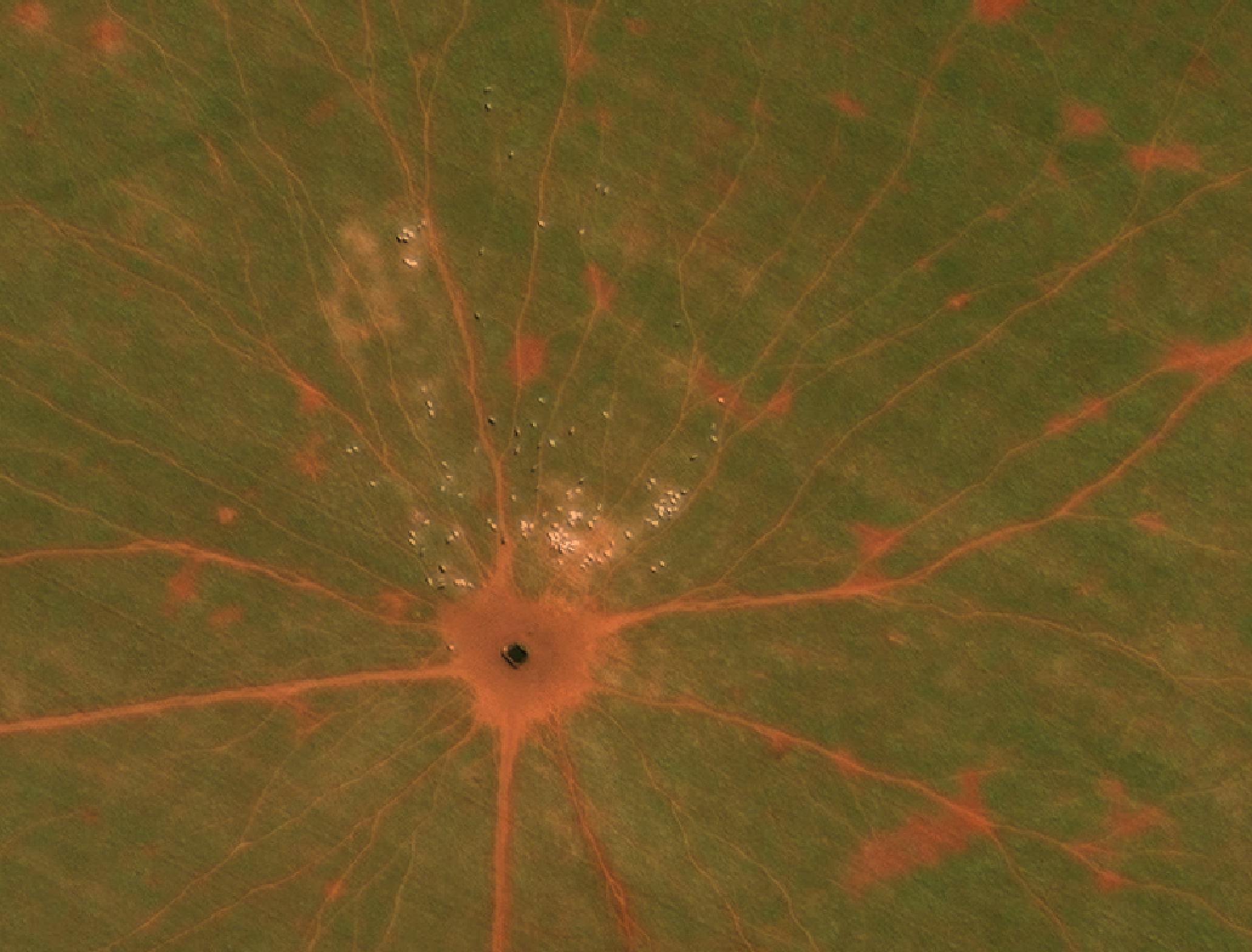 Cattle spotted from space with DigitalGlobe’s very high-resolution satellite imagery.[/caption]
As one of the winners of the DigitalGlobe GBDX Sustainability Challenge, 20tree.ai built on top of these advancements in satellite imagery and artificial intelligence. We adjusted the advancements to fit the needs of land use intelligence. We had access to 100 PB of imagery in DigitalGlobe’s 18 year archive through GBDX. With these historical images we could identify patterns in land use and land use change on the most granular level – as was not done before on this scale. This means cattle, degraded forest, crop type and logging roads are labeled separately across the Cerrado. These newly labeled imagery were used to develop novel algorithms. The algorithms developed have three levels:
Cattle spotted from space with DigitalGlobe’s very high-resolution satellite imagery.[/caption]
As one of the winners of the DigitalGlobe GBDX Sustainability Challenge, 20tree.ai built on top of these advancements in satellite imagery and artificial intelligence. We adjusted the advancements to fit the needs of land use intelligence. We had access to 100 PB of imagery in DigitalGlobe’s 18 year archive through GBDX. With these historical images we could identify patterns in land use and land use change on the most granular level – as was not done before on this scale. This means cattle, degraded forest, crop type and logging roads are labeled separately across the Cerrado. These newly labeled imagery were used to develop novel algorithms. The algorithms developed have three levels:
- Semantic segmentation: to classify land use and objects on pixel level, the latest deep learning models for semantic segmentation have been used as basis: SegNet and U-Net.
- Ensemble: an ensemble of the outputs of the segmentation models is created to increase accuracy.\
- Temporal dimension: by combining ensembles of very high and medium resolution satellite imagery in a Recurrent Neural Network (RNN), the insights can constantly be updated once new imagery becomes available - regardless the spatial resolution.
 Monitoring land use over time with very high- to
medium-resolution satellite imagery.[/caption] As a result, the final model is able to find new patterns and detect small and large changes in the Cerrado with higher accuracy and on a more frequent basis. This makes the insights actionable. By detecting the cattle on the ground, we are able to see which pasture lands are actively being used. Abandoned land can be re-used for agriculture - reducing the need for deforestation - or land can be used for reforestation. It also allows us to have a closer look at biomass above the ground on tree level. This can be used to determine carbon stock more precisely. 20tree.ai is sharing these insights with NGOs, corporations and financial institutions. NGOs use this information to inform their resources on the ground and to make decisions based on the latest information. For example, the latest insights on sustainable land use management are shared with local farmers. Corporations use these insights to monitor if they and their suppliers adhere to their zero-deforestation commitments so that they can response in an earlier stage. For financial institutions, zero-deforestation and no loss of native vegetation should be a precondition for all investments. Up-to-date insights and insights on the most granular level facilitate all parties in the supply chain to take action. Open innovation with the global community is crucial to make this movement bigger and 20tree.ai will publish results, including algorithms and ground truth labels, to push innovation for planet intelligence.