Real Technology, Real Benefits is a series of articles that explores the connection between satellite imaging technology and real-world applications and benefits. Read Part 1: pointing agility.
In the last post we talked about how pointing agility, combined with a large aperture telescope, enables our satellites to look far off nadir to collect an image without having to wait for the satellite to pass directly over the target—giving us the ability to react quickly to world events such as disasters. We also explored how off-nadir viewing enables our satellites to see the world at different times of day, from 9:30 a.m. to 2:30 p.m, local time.
These two characteristics (agility and aperture) bring other benefits as well. One of these is the ability to collect large areas in a single pass. Our satellites “paint” the ground much like a paint roller as they zip around the globe at 18,000 miles per hour. A satellite is in view of a particular location on the ground for only a few minutes, and once it’s out of range, you have to wait for the next satellite to pass overhead. So the faster your paint roller can “sweep,” and the wider its collection swath, the more imagery you can collect in that limited amount of time.
Why does this matter? First, the world is a big place—even a city is a big place. While a particular application may be interested in looking at, say, parking lots, there are thousands of parking lots in a city. It’s much easier to collect the entire area than it is to try to collect the parking lots one at a time, much like it is easier to use a roller to paint a wall than a tiny brush.
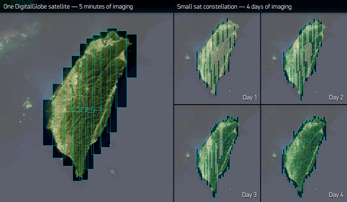
In the example below, one of our customers needed new imagery of Taiwan as quickly as possible this summer. We tasked our WorldView-2 satellite to image the entire 14,000-square mile island in a single overhead pass, “painting” it with 15 image strips collected in just five minutes (shown on the left). A large constellation of small satellites could only collect a fraction of the area in this amount of time; collecting the whole island would take several days to accomplish, and changing weather conditions add even more uncertainty to this scenario. The notional example on the right shows what a small satellite constellation could collect over four days, based on a constellation of 12 satellites with reaction wheels and 35 cm camera apertures imaging the ground at 1.2 meter resolution or better, comparable to Skybox Imaging’s future capability.
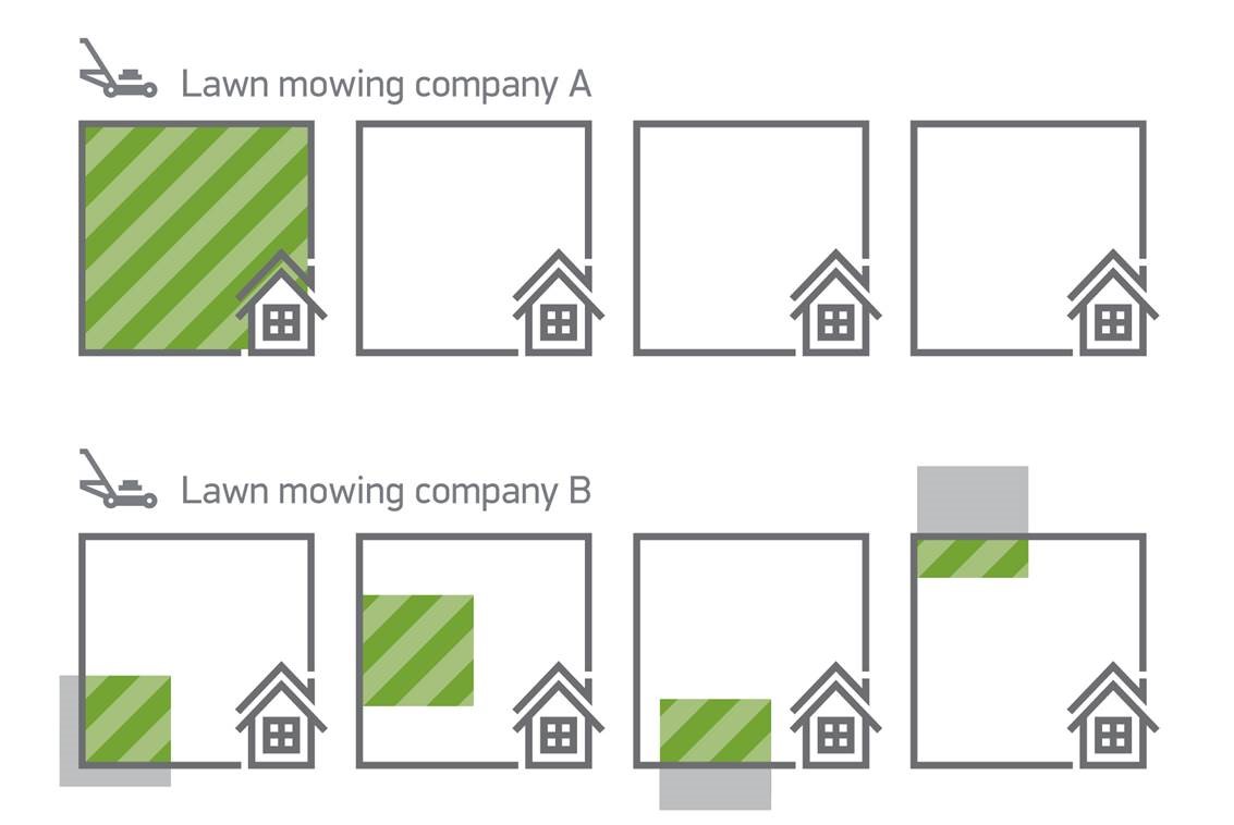
The need for complete coverage of large areas is important for the vast majority of satellite imaging applications—whether it is to analyze activity in an oil basin, or to manage infrastructure across a city or state. The total area that a satellite constellation can collect is less important than its ability to collect the right areas for its customers. Imagine two lawn mowing companies that service the lawns in your neighborhood. One can mow 100% of 25% of the lawns in a neighborhood every week. The other can mow 25% of the area in a neighborhood every week — and some of that area isn’t even lawn, because their mowers aren’t all that steerable. Both services collect the same total area, but only one collects useful area. As a homeowner with one lawn to maintain, which service would you use?
Our satellites’ large single-pass collection capacity means we collect the right area in a single pass, satisfying customer needs more quickly than the piecemeal approach, and resulting in a more consistent picture. It also means we are best able to take advantage of those cloud-free days by maximizing how much we collect when we can.
As we said before, the world is a big place. While it’s important to know how quickly a satellite or constellation can image a single city, it’s equally important to know how long it will take to regularly collect, or refresh, imagery of many cities. For example, how long would it take to collect the world’s 5,000 most populous cities, hypothetically using all of a constellation’s capacity? Following the launch of our WorldView-4 satellite next year, we would be able to do this in less than half the time relative to a notional constellation of a dozen 1-meter class small satellites.
[Note that the question is not how many cities can each constellation collect, because like the lawn mower example, it’s not very interesting if 25% of the cities are collected 4 times too often and 75% are not collected at all — they all need to be refreshed within a given time period.]
![How long would it take to collect the world’s 5,000 most populous cities, hypothetically using all of a constellation’s capacity? Following the launch of our WorldView-4 satellite next year, we would be able to do this in less than half the time relative to a notional constellation of a dozen 1-meter class small satellites. [Note that the question is not how many cities can each constellation collect, because like the lawn mower example, it’s not very interesting if 25% of the cities are collected 4 times too often and 75% are not collected at all — they all need to be refreshed within a given time period.]](https://maxar-blog-assets.s3.amazonaws.com/uploads/blogImages/2015/12/5000cities.png)
At first, this result seems surprising: how can fewer satellites collect more frequently than a larger constellation? The answer here also boils down to agility and aperture. Because of their larger aperture, DigitalGlobe satellites have a much larger area over which they can see a given location, which means many more opportunities to collect it at a comparable resolution.
The ability to quickly re-target from one area to another also gives our satellites the ability to image the same area many times in a short period of time. Our multi-shot capability allows customers to monitor change at a certain location over several minutes, albeit at the expense of imaging many other areas during that time. In the example below, our WorldView-2 satellite imaged Galeão International Airport in Brazil, collecting 30 images over seven minutes – a much longer dwell time as compared to less agile, small-aperture satellites.
Practically speaking, there aren’t many use cases for the type of video-like monitoring shown above, because it requires a tremendous amount of satellite capacity to deliver very brief and sporadic results, even with a huge swarm of satellites. More often, users need to see a particular location once per day or several times per day. The DigitalGlobe constellation can see any point on the globe multiple times per day, and our customers are typically interested in parts of the world where change happens most frequently – urban areas. The compilation below shows Sydney, Australia, which we’ve imaged more than 40 times so far this year. All of these images were captured at 50 cm resolution or better, and that stunning level of detail is on full display in our most recent image from November 30 that you can see here (the water slides on that Carnival cruise ship look like fun, don’t they?).
Now, other imagery providers are fond of pointing out that much of our satellite capacity is already spoken for, whereas their customers will enjoy on-demand access to new imagery of any place on the earth. That may be true for the first few customers, but it’s not sustainable. Imagine a global airline flying routes with only one passenger per plane. In a capital-intensive business like commercial aviation, they won’t be around for very long. Over the past 15 years, DigitalGlobe has proven it’s built to last. Moreover, because there is customer demand, next year we’ll vastly expand access to 30 cm satellite imagery with the launch of WorldView-4.
At the end of the day, when one satellite can do the job of many, it’s not about the size (or cost) of the tool, but rather how much it delivers per unit of cost. Shovels are cheaper than bulldozers, yet we use bulldozers to build roads, because a bulldozer can produce more road per dollar than a truckload of shovels. It’s the same with satellites.
In the next edition of Real Technology, Real Benefits, we’ll explore how image quality can be the difference between making a decision and making the right decision.