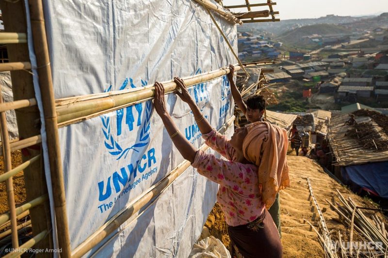
 As the number of forcibly displaced people increases, construction of new refugee camps and the expansion of existing ones is vital. With this comes a need to ensure camps are being built and maintained efficiently and sustainably with respect to location of shelters, water sources and other variables.
Camp mapping is essential but labor intensive as field staff typically survey the camps on the ground and upload the data manually. By harnessing the power of satellite imagery from Maxar Technologies’ DigitalGlobe with machine learning, this mapping project aims to reduce the amount of labor and staff time needed to monitor camp growth and utilization and allow for UNHCR to expand other program areas that assist refugees.
As the number of forcibly displaced people increases, construction of new refugee camps and the expansion of existing ones is vital. With this comes a need to ensure camps are being built and maintained efficiently and sustainably with respect to location of shelters, water sources and other variables.
Camp mapping is essential but labor intensive as field staff typically survey the camps on the ground and upload the data manually. By harnessing the power of satellite imagery from Maxar Technologies’ DigitalGlobe with machine learning, this mapping project aims to reduce the amount of labor and staff time needed to monitor camp growth and utilization and allow for UNHCR to expand other program areas that assist refugees.
 Out of the 202 UNHCR refugee camps, 116 will be mapped using Tomnod and machine learning while following similar shelter mapping methodology currently used by UNOSAT and UNHCR.
Using DigitalGlobe satellite imagery, individuals can tag shelters in refugee camps. There are four types of structures that need to be identified within each refugee camp: tents, improvised, semi-permanent and administrative shelters.
[caption id="" align="aligncenter" width="800"]
Out of the 202 UNHCR refugee camps, 116 will be mapped using Tomnod and machine learning while following similar shelter mapping methodology currently used by UNOSAT and UNHCR.
Using DigitalGlobe satellite imagery, individuals can tag shelters in refugee camps. There are four types of structures that need to be identified within each refugee camp: tents, improvised, semi-permanent and administrative shelters.
[caption id="" align="aligncenter" width="800"]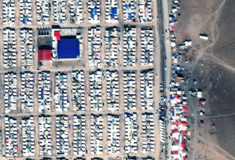 This DigitalGlobe satellite image shows the Domiz Refugee camp in Bajerke Dumez, Iraqi Kurdistan. The larger blue and red roofed structures are administration buildings. Most of the buildings in this image are tent shelters. And on the right side of the image, outside the camp boundary, there is a collection of improvised shelters and commerce tents.[/caption]
Once the data is tagged, the Hive will work with Stanford University Sustainability and Artificial Intelligence Lab to automatically identify and count tent features from satellite imagery of other UNHCR refugee camps using convolutional neural network models.
The imagery data will be shared on OpenStreetMap and UN Humanitarian Data Exchange Portal, open source data platforms that are available to other UN agencies and international relief organizations.
Help us automate the process of mapping growing refugee camps. By tagging the shelters in refugee camps, you will assist UNHCR in their mission to safeguard the well-being of refugees.
To participate in helping the Hive to identify structures within refugee camps, please join the Tomnod campaign.
Learn more about USA for UNHCR’s innovation lab, The Hive, at www.UNrefugees.org. On Twitter at @UNRefugeeAgency.
This DigitalGlobe satellite image shows the Domiz Refugee camp in Bajerke Dumez, Iraqi Kurdistan. The larger blue and red roofed structures are administration buildings. Most of the buildings in this image are tent shelters. And on the right side of the image, outside the camp boundary, there is a collection of improvised shelters and commerce tents.[/caption]
Once the data is tagged, the Hive will work with Stanford University Sustainability and Artificial Intelligence Lab to automatically identify and count tent features from satellite imagery of other UNHCR refugee camps using convolutional neural network models.
The imagery data will be shared on OpenStreetMap and UN Humanitarian Data Exchange Portal, open source data platforms that are available to other UN agencies and international relief organizations.
Help us automate the process of mapping growing refugee camps. By tagging the shelters in refugee camps, you will assist UNHCR in their mission to safeguard the well-being of refugees.
To participate in helping the Hive to identify structures within refugee camps, please join the Tomnod campaign.
Learn more about USA for UNHCR’s innovation lab, The Hive, at www.UNrefugees.org. On Twitter at @UNRefugeeAgency.