At the intersection of people, process and technology…
As part of our continual efforts to improve the quality of service we provide to our customers, we’ve formalized an upgraded process to determine where we aim our sensors. It’s called our Content Planning Program (CPP) and is equal parts science and art. CPP takes in inputs required to perform efficient medium- and long-term planning for the constellation—including customer tasking orders, product content collection requirements, weather modeling considerations and more. Our planners use CPP to digest all of this information and figure out the optimum approach and timing to collect relevant imagery. They then generate a prioritized plan for our tactical Constellation Scheduling System (CSS), which creates the instructions our sensors follow to collect images along the satellites’ orbit. CSS requires only 90 minutes of lead time to adjust to the scheduling team’s manual inputs!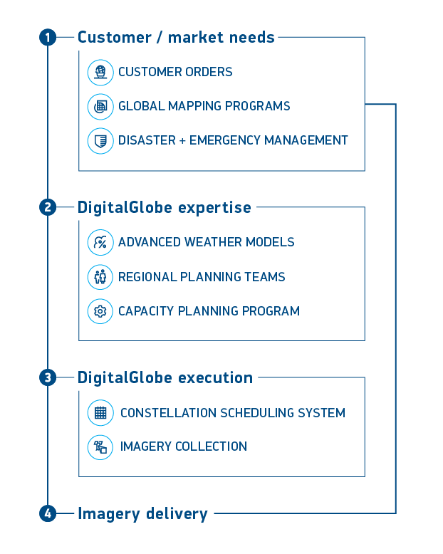 With our recent improvements, the entire system reacts quickly to tactical changes that arise from changing weather conditions, demand events or other factors—and as a result, we are maximizing our growing constellation capacity more than ever before.
Of course, at the end of the day, specific, regional knowledge is still an invaluable art—so our regionally aligned planners also provide their unique inputs to the system. Taken in aggregate, our R&D and Satellite Operations teams have hundreds of years of combined experience managing our constellation of very high resolution satellites. For our customers, this combination of art and science means better tasking responsiveness with improved success rates, and a larger and more temporally current image library.
Here’s a great example of how CPP combines sophisticated technology and personal experience. DigitalGlobe recently made a concerted effort to significantly expand our library of recent imagery in the Asia Pacific region—a notoriously tough-to-collect area of interest (AOI) because of cloud cover. One of our experienced collection planners knew that typhoons in the South Pacific could impact normal cloud formation and temporarily allow for high-quality collection over areas that are normally obscured. We incorporated this input into CPP, and as our planner predicted the typhoon moved the clouds right on schedule, the skies cleared, and we collected a massive amount of high-quality nearly cloud-free data.
DigitalGlobe is the industry leader in high-resolution satellite imagery. We provide, maintain and continuously expand the world’s largest library of top-quality satellite imagery. In fact, DigitalGlobe collects more high-resolution satellite imagery than all other commercial vendors combined! The expansiveness of our library is partially due to our long history in the Earth imaging business, but our large and growing satellite constellation and our advanced collection planning strategies also play a big part in maintaining our leadership and growth.
The care we put into our collection planning means that you have a better chance of getting the high-quality image you need in your AOI from DigitalGlobe than any other provider. And we’re not nearly done—we are making advancements in imagery availability every day. DigitalGlobe is committed to improving our capabilities and continuously expanding imagery availability moving forward—helping you “See a Better World” in your AOI.
Learn more about how we maximize image availability here.
With our recent improvements, the entire system reacts quickly to tactical changes that arise from changing weather conditions, demand events or other factors—and as a result, we are maximizing our growing constellation capacity more than ever before.
Of course, at the end of the day, specific, regional knowledge is still an invaluable art—so our regionally aligned planners also provide their unique inputs to the system. Taken in aggregate, our R&D and Satellite Operations teams have hundreds of years of combined experience managing our constellation of very high resolution satellites. For our customers, this combination of art and science means better tasking responsiveness with improved success rates, and a larger and more temporally current image library.
Here’s a great example of how CPP combines sophisticated technology and personal experience. DigitalGlobe recently made a concerted effort to significantly expand our library of recent imagery in the Asia Pacific region—a notoriously tough-to-collect area of interest (AOI) because of cloud cover. One of our experienced collection planners knew that typhoons in the South Pacific could impact normal cloud formation and temporarily allow for high-quality collection over areas that are normally obscured. We incorporated this input into CPP, and as our planner predicted the typhoon moved the clouds right on schedule, the skies cleared, and we collected a massive amount of high-quality nearly cloud-free data.
DigitalGlobe is the industry leader in high-resolution satellite imagery. We provide, maintain and continuously expand the world’s largest library of top-quality satellite imagery. In fact, DigitalGlobe collects more high-resolution satellite imagery than all other commercial vendors combined! The expansiveness of our library is partially due to our long history in the Earth imaging business, but our large and growing satellite constellation and our advanced collection planning strategies also play a big part in maintaining our leadership and growth.
The care we put into our collection planning means that you have a better chance of getting the high-quality image you need in your AOI from DigitalGlobe than any other provider. And we’re not nearly done—we are making advancements in imagery availability every day. DigitalGlobe is committed to improving our capabilities and continuously expanding imagery availability moving forward—helping you “See a Better World” in your AOI.
Learn more about how we maximize image availability here.