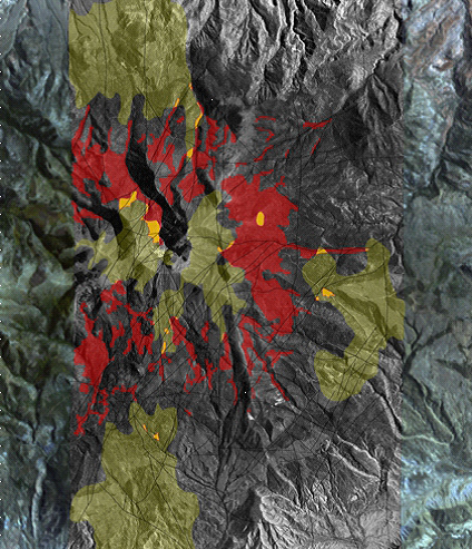
 The 3-D Bare Rock Model© classifies satellite data to differentiate rock and formation types. This mineral classification map shows areas containing high concentrations of copper (red) and feldspar (green). Locations of spatial correlation of copper and feldspar are identified (yellow) prospective targets. Image produced by Auracle Remote Sensing.[/caption]
“With this new relationship with DigitalGlobe, Auracle Remote Sensing looks forward to maximizing the value of spatial data for global mining and mineral exploration companies. Our data integration and fusion methodologies are a great match to DigitalGlobe’s satellite products. Auracle has developed a specialized 3-D Bare Rock Model© that combines radar and optical satellite data. Synthetic Aperture Data (SAR), one type of satellite imagery used in the process, is not affected by weather or atmospheric conditions. It penetrates vegetation, ground cover, rocks and soils to identify buried structure and alterations. Auracle is especially excited about combining our technical expertise in structural analysis with DigitalGlobe’s super-spectral WorldView-3, the most advanced commercial, high-resolution satellite imagery,” said David McLelland, Auracle Remote Sensing’s President.
Economic mineral and energy deposits are increasingly difficult to detect with most of the obvious deposits mined. Explorers are now focused on more remote areas which may be covered by forest, ice, water or agriculture. “The ability to look through land cover, rock or soils that are laying over a mineral deposit is a great advantage in geological mapping. We can expand the search for precious and base-metal mineral occurrences into deeper areas. Auracle’s upgraded mineral maps, structural analyses and predictive models help our clients to narrow prospective targets and bring down the costs of making new, deeper discoveries. For operating mines, existing knowledge about the known deposit is applied to the Model to identify near-but yet unexplored targets,” said McLelland.
To learn more about DigitalGlobe’s Information Partner Program, visit digitalglobe.com/partners/information-partners.
To contact Auracle Remote Sensing, email info@auracleremotesensing.com.
The 3-D Bare Rock Model© classifies satellite data to differentiate rock and formation types. This mineral classification map shows areas containing high concentrations of copper (red) and feldspar (green). Locations of spatial correlation of copper and feldspar are identified (yellow) prospective targets. Image produced by Auracle Remote Sensing.[/caption]
“With this new relationship with DigitalGlobe, Auracle Remote Sensing looks forward to maximizing the value of spatial data for global mining and mineral exploration companies. Our data integration and fusion methodologies are a great match to DigitalGlobe’s satellite products. Auracle has developed a specialized 3-D Bare Rock Model© that combines radar and optical satellite data. Synthetic Aperture Data (SAR), one type of satellite imagery used in the process, is not affected by weather or atmospheric conditions. It penetrates vegetation, ground cover, rocks and soils to identify buried structure and alterations. Auracle is especially excited about combining our technical expertise in structural analysis with DigitalGlobe’s super-spectral WorldView-3, the most advanced commercial, high-resolution satellite imagery,” said David McLelland, Auracle Remote Sensing’s President.
Economic mineral and energy deposits are increasingly difficult to detect with most of the obvious deposits mined. Explorers are now focused on more remote areas which may be covered by forest, ice, water or agriculture. “The ability to look through land cover, rock or soils that are laying over a mineral deposit is a great advantage in geological mapping. We can expand the search for precious and base-metal mineral occurrences into deeper areas. Auracle’s upgraded mineral maps, structural analyses and predictive models help our clients to narrow prospective targets and bring down the costs of making new, deeper discoveries. For operating mines, existing knowledge about the known deposit is applied to the Model to identify near-but yet unexplored targets,” said McLelland.
To learn more about DigitalGlobe’s Information Partner Program, visit digitalglobe.com/partners/information-partners.
To contact Auracle Remote Sensing, email info@auracleremotesensing.com.